IMAGES TAKEN NEAR TO
Brent Road, HIGHBRIDGE, TA9 4JD
Introduction
This page details the photographs taken nearby to Brent Road, TA9 4JD by members of the Geograph project.
The Geograph project started in 2005 with the aim of publishing, organising and preserving representative images for every square kilometre of Great Britain, Ireland and the Isle of Man.

There are currently over 7.5m images from over14,400 individuals and you can help contribute to the project by visiting https://www.geograph.org.uk
Image Map (Loading...)


Getting Data...Please wait
Leaflet Map data © OpenStreetMap
Images are licensed for reuse under creativecommons.org/licenses/by-sa/2.0
Notes
- Clicking on the map will re-center to the selected point.
- The higher the marker number, the further away the image location is from the centre of the postcode.
Image Listing (132 Images Found)
Images are licensed for reuse under creativecommons.org/licenses/by-sa/2.0
Image
Details
Distance
1
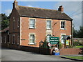
Anvil House
Nowadays it is the Brent Area Medical Centre, but the datestone of 1889 and the name suggests it was a smithy in a previous time.
Image: © Neil Owen
Taken: 15 Sep 2021
0.04 miles
2
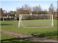
A short game
East Brent has a little patch of land on the corner of the road through the village. It affords a chance for players of a youthful nature to enjoy a kickabout without the need to cover lots of ground.
Image: © Neil Owen
Taken: 15 Feb 2016
0.06 miles
3
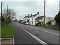
Cottages on Brent Road
A date stone over a cottage called The Stores is recorded as 1797.
Image: © Anthony Vosper
Taken: 7 Apr 2018
0.06 miles
4
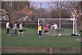
East Brent : Village Green
Looking towards people playing football in the park.
Image: © Lewis Clarke
Taken: 6 Apr 2015
0.06 miles
5
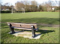
Seating for the match
A typical bench, right in front of the playing field. Incidentally, the 'pitch' is barely forty metres long.
Image: © Neil Owen
Taken: 15 Feb 2016
0.06 miles
6
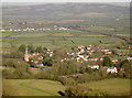
East Brent from the Knoll
The distinctive spire of St Mary the Blessed Virgin is an obvious landmark. The smaller village of Edingworth lies to the north.
Image: © Neil Owen
Taken: 5 Jan 2017
0.07 miles
8
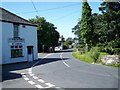
No longer a butcher's
Davies the family butcher has closed Image There is a benchmark on the near corner of the building https://www.geograph.org.uk/photo/6618932.
Image: © Neville Goodman
Taken: 27 Sep 2020
0.07 miles
9
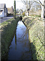
Brent Road rhyne
One of the many drainage features in this part of Somerset.
Image: © Neil Owen
Taken: 15 Feb 2016
0.08 miles
10
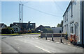
Benchmark on the old butcher's
The OS description is CORNER HO CHURCH RD E FACE N ANG. The building used to be a butcher's shop Image Image
Image: © Neville Goodman
Taken: 27 Sep 2020
0.08 miles