IMAGES TAKEN NEAR TO
Wickmoor, BRIDGWATER, TA7 0JR
Introduction
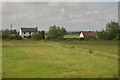
This page details the photographs taken nearby to Wickmoor, TA7 0JR by members of the Geograph project.
The Geograph project started in 2005 with the aim of publishing, organising and preserving representative images for every square kilometre of Great Britain, Ireland and the Isle of Man.

There are currently over 7.5m images from over14,400 individuals and you can help contribute to the project by visiting https://www.geograph.org.uk
Image Map
Images are licensed for reuse under creativecommons.org/licenses/by-sa/2.0
Notes
- Clicking on the map will re-center to the selected point.
- The higher the marker number, the further away the image location is from the centre of the postcode.
Image Listing (40 Images Found)
Images are licensed for reuse under creativecommons.org/licenses/by-sa/2.0
Image
Details
Distance
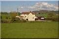
8
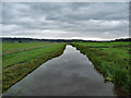
Sowy River near Oath
Water is a relentless enemy in these parts - the whole area is criss-crossed by waterways and festooned with neo-Georgian pumping stations. The Sowy is man-made, in 1969-72, to take excess water from the River Parrett to the King's Sedgemoor Drain.
Image: © Stephen Richards
Taken: 11 Aug 2017
0.15 miles