IMAGES TAKEN NEAR TO
Liney Road, BRIDGWATER, TA7 0EU
Introduction
This page details the photographs taken nearby to Liney Road, TA7 0EU by members of the Geograph project.
The Geograph project started in 2005 with the aim of publishing, organising and preserving representative images for every square kilometre of Great Britain, Ireland and the Isle of Man.

There are currently over 7.5m images from over14,400 individuals and you can help contribute to the project by visiting https://www.geograph.org.uk
Image Map
Images are licensed for reuse under creativecommons.org/licenses/by-sa/2.0
Notes
- Clicking on the map will re-center to the selected point.
- The higher the marker number, the further away the image location is from the centre of the postcode.
Image Listing (23 Images Found)
Images are licensed for reuse under creativecommons.org/licenses/by-sa/2.0
Image
Details
Distance
1
Young and curious
A fine looking fellow leaves the rest of a small herd and approaches. He looks like one of this year's crop.
Image: © Neil Owen
Taken: 10 Sep 2015
0.06 miles
3
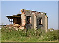
Still useful to someone
An old hut at the north-west part of the old Westonzoyland airfield is not as it was originally. However, it still serves a purpose for the gardening community.
Image: © Neil Owen
Taken: 10 Sep 2015
0.08 miles
4
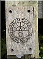
Mary Michael Pilgrims Way
One of Britain's longer distance walking routes, the Mary Michael Pilgrim Way is a fairly recent creation. It originally went from Brentor (west Dartmoor) to Glastonbury and was completed in 2011. However, the urge to extend it brought about the possibility to travel from the cliff tops of West Cornwall at Carn Lês Boel near Land’s End to Hopton on the Norfolk Coast. Here the path is marked, informally, as it wends its way across the Somerset Levels and the former airbase of Westonzoyland.
Image: © Neil Owen
Taken: 10 Sep 2015
0.11 miles
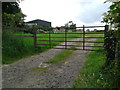
5
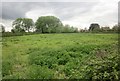
Field at Liney
Looking to the right from the same spot as Image], with Upper Liney Farm on the right. That weather doesn't look very good, does it?
Image: © Derek Harper
Taken: 25 Apr 2015
0.12 miles
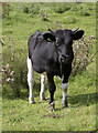
6
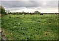
Cattle. Liney
From the junction of Liney Road with footpath 40UC052 BW 36/8, which follows the track you can see bending around on the left. The further trees are among the northwest vestiges of Westonzoyland Airfield.
Image: © Derek Harper
Taken: 25 Apr 2015
0.14 miles
7
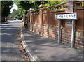
Cheer Lane
This old lane existed well before these modern houses appeared - and a lovely place it is too!
Image: © Neil Owen
Taken: 10 Sep 2015
0.15 miles
8
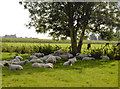
Sheep shade
A flock of woolly fellows grab all the shade afforded by the tree on a warm September afternoon. Presumably they had been fleeced earlier in the year and their coats are new growth, although the cattle in the next field are left in the open. They are not so daft, sheep - they know how to avoid the h-ewe-midity...
Image: © Neil Owen
Taken: 10 Sep 2015
0.16 miles
9

Westonzoyland village hall
This community facility was, as its styling suggests, formerly a military building. The nearby R.A.F. Westonzoyland station was an occasional airfield from its founding in 1926, but the advent of WWII brought a vast increase in men and machinery. This building dates from 1942 and was used as a cinema and gymnasium. Later, after the end of hostilities, it became the village school but is now the hall, residing by the recreation ground.
Image: © Neil Owen
Taken: 10 Sep 2015
0.17 miles