IMAGES TAKEN NEAR TO
Watery Lane, BRIDGWATER, TA6 6SY
Introduction
This page details the photographs taken nearby to Watery Lane, TA6 6SY by members of the Geograph project.
The Geograph project started in 2005 with the aim of publishing, organising and preserving representative images for every square kilometre of Great Britain, Ireland and the Isle of Man.

There are currently over 7.5m images from over14,400 individuals and you can help contribute to the project by visiting https://www.geograph.org.uk
Image Map (Loading...)


Getting Data...Please wait
Leaflet Map data © OpenStreetMap
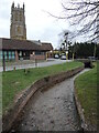
Images are licensed for reuse under creativecommons.org/licenses/by-sa/2.0
Notes
- Clicking on the map will re-center to the selected point.
- The higher the marker number, the further away the image location is from the centre of the postcode.
Image Listing (143 Images Found)
Images are licensed for reuse under creativecommons.org/licenses/by-sa/2.0
Image
Details
Distance
1
North Petherton library
A facility of the small town between Bridgwater and Taunton.
The building dates to the 1980's.
Image: © Jonathan Billinger
Taken: 18 Dec 2009
0.01 miles
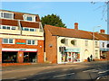
2
North Petherton: Lloyds Pharmacy and Craftsmen Furnishers
Image: © Michael Garlick
Taken: 26 Jun 2019
0.01 miles
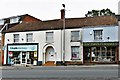
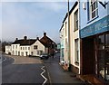
3
Houses in North Petherton
These buildings on Fore Street are also shown in Image The two right-hand buildings were formerly the George Inn, originally C17 http://www.imagesofengland.org.uk/Details/Default.aspx?id=269338&mode=adv .
Image: © Derek Harper
Taken: 16 Jan 2010
0.02 miles
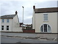
4
North Petherton : Fore Street A38
Fore Street heading through North Petherton.
Image: © Lewis Clarke
Taken: 20 Feb 2016
0.02 miles
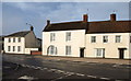
5
A hotel by the stream
A former hotel, with large arched windows, stands beside the mill stream which is now under the road.
Image: © Neil Owen
Taken: 23 Feb 2023
0.02 miles
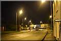
6
North Petherton bridge
As with many Somerset County Council bridges, this one has an inscribed set of coping stones - probably early twentieth century. Interestingly, Fore Street was largely demolished and widened in the 1960s and this bridge has been rebuilt with brick. Notably, the original stones were retained.
Image: © Neil Owen
Taken: 23 Feb 2023
0.02 miles
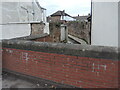
7
Checking the mill stream
North Petherton bridge spans the old mill waters as they pass through the middle of town. Although rebuilt many times, the spot seems to be a concern as a level monitor (the green tube) is stationed here.
Image: © Neil Owen
Taken: 23 Feb 2023
0.02 miles
8
Fore Street, North Petherton
The buildings on the left also appear in Image, and see Image The shops on the right are seen in reverse in Image
Image: © Derek Harper
Taken: 16 Jan 2010
0.02 miles
9
The stream by the community centre
North Petherton community centre stands near the waters and St Mary's church. In the past this area was covered with crowded houses, shops and a Sunday school. They are all gone now after the road was widened and took out a lot of the old buildings (revealing Saxon remains under them).
The town had yearned for a centre since the 1920s but took many years to gather sufficient sums to purchase the land. By the 1980s a caravan was put into service as a makeshift shop to raise more money. Plans by the council to build houses here were defeated and so the community centre was officially opened on 21st March, 1987, by Lieutenant Colonel Walter Luttrell, Lord Lieutenant of Somerset. Further extensions happened in 1991.
Image: © Neil Owen
Taken: 23 Feb 2023
0.03 miles
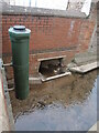
10
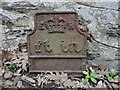
Utility marker on Fore Street
A cast iron marker (presumably for telephonic systems) remains in the ground by houses. Its use is now long disregarded but forms part of the local history. See Image] for a location view.
Image: © Neil Owen
Taken: 23 Feb 2023
0.03 miles