IMAGES TAKEN NEAR TO
Hammet Street, BRIDGWATER, TA6 6SD
Introduction
This page details the photographs taken nearby to Hammet Street, TA6 6SD by members of the Geograph project.
The Geograph project started in 2005 with the aim of publishing, organising and preserving representative images for every square kilometre of Great Britain, Ireland and the Isle of Man.

There are currently over 7.5m images from over14,400 individuals and you can help contribute to the project by visiting https://www.geograph.org.uk
Image Map (Loading...)


Getting Data...Please wait
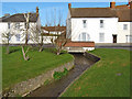
Leaflet Map data © OpenStreetMap
Images are licensed for reuse under creativecommons.org/licenses/by-sa/2.0
Notes
- Clicking on the map will re-center to the selected point.
- The higher the marker number, the further away the image location is from the centre of the postcode.
Image Listing (149 Images Found)
Images are licensed for reuse under creativecommons.org/licenses/by-sa/2.0
Image
Details
Distance
1
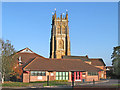
North Petherton Community Centre
With St Mary's Church tower behind
Image: © Ken Grainger
Taken: 11 Oct 2008
0.01 miles
2
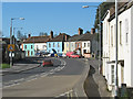
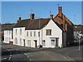
Fore Street, North Petherton
The colourful houses in the background also appear in Image In the foreground is the entrance to Crosswell Close. Across the road and a pedestrian crossing is the post office.
Image: © Derek Harper
Taken: 16 Jan 2010
0.04 miles
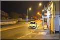
3
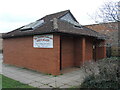
The daytime loos are open again!
A banner proclaims the joy of having a W.C. back in use. They were under the control of the Sedgemoor District Council but it sold them to the adjoining community centre. Then a fire broke out in 2014 - vandalism, no doubt - that closed them. Only recently has the block been restored to full use - much to the relief of many!
Image: © Neil Owen
Taken: 23 Feb 2023
0.04 miles
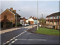
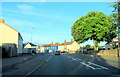
5
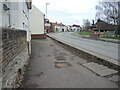
North Petherton : Fore Street A38
Looking along Fore Street as it heads through North Petherton.
Image: © Lewis Clarke
Taken: 20 Feb 2016
0.04 miles
7
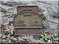
Utility marker on Fore Street
A cast iron marker (presumably for telephonic systems) remains in the ground by houses. Its use is now long disregarded but forms part of the local history. See Image] for a location view.
Image: © Neil Owen
Taken: 23 Feb 2023
0.05 miles
8
Along Fore Street
North Petherton's main road crosses the mill stream here, but there is little remnant of an imperial measurement past - see Image] for a look at a cast iron marker at the foot of the wall.
Image: © Neil Owen
Taken: 23 Feb 2023
0.05 miles
9
Junction of A38 and Watery Lane, North Petherton
Image: © Ken Grainger
Taken: 22 Mar 2009
0.05 miles