IMAGES TAKEN NEAR TO
Enmore, BRIDGWATER, TA5 2EE
Introduction
This page details the photographs taken nearby to TA5 2EE by members of the Geograph project.
The Geograph project started in 2005 with the aim of publishing, organising and preserving representative images for every square kilometre of Great Britain, Ireland and the Isle of Man.

There are currently over 7.5m images from over14,400 individuals and you can help contribute to the project by visiting https://www.geograph.org.uk
Image Map
Images are licensed for reuse under creativecommons.org/licenses/by-sa/2.0
Notes
- Clicking on the map will re-center to the selected point.
- The higher the marker number, the further away the image location is from the centre of the postcode.
Image Listing (7 Images Found)
Images are licensed for reuse under creativecommons.org/licenses/by-sa/2.0
Image
Details
Distance
1
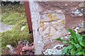
Ordnance Survey Cut Mark
This OS cut mark can be found on the west face of the roadside building at Lower Quantock Farm. It marks a point 102.226m above mean sea level.
Image: © Adrian Dust
Taken: 3 Dec 2017
0.03 miles
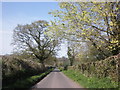
3
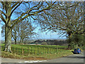
Parkland, Enmore
Part of the landscape park to Enmore Castle, seen from the Barford road. The trees on the right sit in a hollow way, thought to be an earlier route of the Bridgwater to Quantocks turnpike http://webapp1.somerset.gov.uk/her/details.asp?prn=10510 . The route lies through the gateway from this was taken, but the area close to the road has been filled in.
Image: © Derek Harper
Taken: 26 Jul 2010
0.15 miles
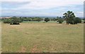
4
Concrete ramp to holloway
See Image, taken on the other side of the Barford road. Here a ramp leads down to the old hollow way, illustrating the difference in levels. The way now runs between field boundaries http://webapp1.somerset.gov.uk/her/details.asp?prn=10510 .
Image: © Derek Harper
Taken: 26 Jul 2010
0.15 miles
6
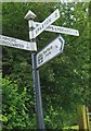
Old Direction Sign - Signpost near Smocombe House, Enmore Parish
Pyramid finial - 4 arms, 1 Worboys; Somerset SCC pyramid by the UC road, in parish of Enmore (Sedgemoor District), lane to Barford Park junction with Enmore Road, by Smocombe House. See https://www.geograph.org.uk/photo/7541487 for a more recent photograph.
Surveyed
Milestone Society National ID: SO_ST2334
Image: © J Dowding
Taken: 1 Jul 2014
0.24 miles
7

Direction Sign – Signpost near Smocombe House in Enmore parish
Located on the south side of the junction near Smocombe House, Enmore parish. The road to the north leads to Barford Park. 3 arms and pyramid finial. See https://www.geograph.org.uk/photo/6044718 for an older photo and http://www.geograph.org.uk/photo/5815215.
Milestone Society National ID: SO_ST2334
Image: © J Dowding
Taken: 20 May 2023
0.24 miles