IMAGES TAKEN NEAR TO
Brett Close, TAUNTON, TA4 4JZ
Introduction
This page details the photographs taken nearby to Brett Close, TA4 4JZ by members of the Geograph project.
The Geograph project started in 2005 with the aim of publishing, organising and preserving representative images for every square kilometre of Great Britain, Ireland and the Isle of Man.

There are currently over 7.5m images from over14,400 individuals and you can help contribute to the project by visiting https://www.geograph.org.uk
Image Map
Images are licensed for reuse under creativecommons.org/licenses/by-sa/2.0
Notes
- Clicking on the map will re-center to the selected point.
- The higher the marker number, the further away the image location is from the centre of the postcode.
Image Listing (22 Images Found)
Images are licensed for reuse under creativecommons.org/licenses/by-sa/2.0
Image
Details
Distance
1
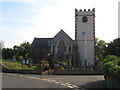
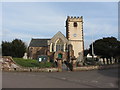
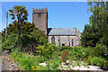
Sampford Brett, Somerset
The church of St George
Image: © ChurchCrawler
Taken: 12 Sep 2005
0.05 miles
2

SCC Fingerpost at Sampford Brett
Very nicely cut around.
Image: © Andrew Riley
Taken: 4 Jun 2018
0.08 miles
4
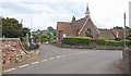
Old School, Sampford Brett
Although the building is recorded at http://webapp1.somerset.gov.uk/her/details.asp?prn=19374 , no date is given, though it's clearly Victorian. On the left are the wall and railings surroundeing the churchyard of St George's church, shown in Image
Image: © Derek Harper
Taken: 30 Jun 2010
0.09 miles
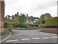
6
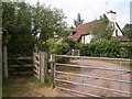
Gates to Sampford Brett
By which the Coleridge Way and Macmillan Way West, having shared footpath WL 20/2, enter the village along Croft Meadow.
Image: © Derek Harper
Taken: 30 Jun 2010
0.10 miles
7
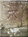
Ordnance Survey Cut Mark
This OS cut mark can be found on the SW face of St George's Church. It marks a point 33.136m above mean sea level.
Image: © Adrian Dust
Taken: 18 Mar 2016
0.10 miles
9
St George's church, Sampford Brett
Another view of the church shown in Image, with its battlemented C14 tower on the south side. "No-one could call the W front pretty", says Pevsner in 1958, continuing: "the imitation Gothic tracery here is monstrously ignorant and aesthetically of no value", but http://webapp1.somerset.gov.uk/her/details.asp?prn=34660 explains "West porch ... added, restored 1960-2 after World War 2 damage, West windows rebuilt 1967", so perhaps the appearance has changed since. It does look a little odd, however.
Image: © Derek Harper
Taken: 30 Jun 2010
0.11 miles
10
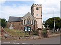
St George's
Church at Sampford Brett.
Image: © Wayland Smith
Taken: 7 Jun 2015
0.11 miles