IMAGES TAKEN NEAR TO
Gatchell Lane, TAUNTON, TA4 4FA
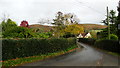
Introduction
This page details the photographs taken nearby to Gatchell Lane, TA4 4FA by members of the Geograph project.
The Geograph project started in 2005 with the aim of publishing, organising and preserving representative images for every square kilometre of Great Britain, Ireland and the Isle of Man.

There are currently over 7.5m images from over14,400 individuals and you can help contribute to the project by visiting https://www.geograph.org.uk
Image Map
Images are licensed for reuse under creativecommons.org/licenses/by-sa/2.0
Notes
- Clicking on the map will re-center to the selected point.
- The higher the marker number, the further away the image location is from the centre of the postcode.
Image Listing (69 Images Found)
Images are licensed for reuse under creativecommons.org/licenses/by-sa/2.0
Image
Details
Distance
1
Sign to pub, Bicknoller
Indicating the way to the Bicknoller Inn, clearly the most in-demand destination in the village. Along Church Lane is the triangle with the oak tree shown in Image
Image: © Derek Harper
Taken: 1 Dec 2018
0.02 miles
2
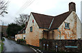
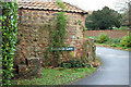
House on Dashwoods Lane, Bicknoller
Gatchells is at the corner with Gatchells Lane (right). The Macmillan Way West follows Dashwoods Lane.
Image: © Derek Harper
Taken: 1 Dec 2018
0.03 miles
3
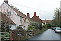
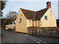
Church Lane, Bicknoller
The house on the left, The Cottage, is listed https://historicengland.org.uk/listing/the-list/list-entry/1345666 . One of the stacks has been taken down.
Image: © Derek Harper
Taken: 1 Dec 2018
0.03 miles
4
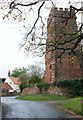
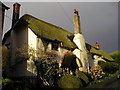
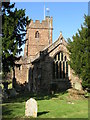
Church, Bicknoller
The grade I listed St George's Church https://historicengland.org.uk/listing/the-list/list-entry/1057465 is shown at http://www.geograph.org.uk/search.php?i=89355844 . Church Lane passes the church and swings right.
Image: © Derek Harper
Taken: 1 Dec 2018
0.03 miles
5
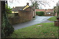
Lane past the church, Bicknoller
Church Lane curves past the church (right); Gatchells Lane turns off to the left.
Image: © Derek Harper
Taken: 1 Dec 2018
0.03 miles
6
Bicknoller, Somerset
The church of St George built of local warm red sandstone.
Image: © ChurchCrawler
Taken: 12 Sep 2005
0.03 miles
7
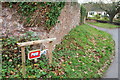
Mounting block, Bicknoller
I think this must be the listed mounting block described at https://historicengland.org.uk/listing/the-list/list-entry/1345667 , although it is not where indicated on the English Heritage map, though it was listed in 1984. "3 steps facing North" - if so, read "northwest" for "north".
Image: © Derek Harper
Taken: 1 Dec 2018
0.03 miles