IMAGES TAKEN NEAR TO
Lydeard St. Lawrence, TAUNTON, TA4 3RX
Introduction
This page details the photographs taken nearby to TA4 3RX by members of the Geograph project.
The Geograph project started in 2005 with the aim of publishing, organising and preserving representative images for every square kilometre of Great Britain, Ireland and the Isle of Man.

There are currently over 7.5m images from over14,400 individuals and you can help contribute to the project by visiting https://www.geograph.org.uk
Image Map
Images are licensed for reuse under creativecommons.org/licenses/by-sa/2.0
Notes
- Clicking on the map will re-center to the selected point.
- The higher the marker number, the further away the image location is from the centre of the postcode.
Image Listing (14 Images Found)
Images are licensed for reuse under creativecommons.org/licenses/by-sa/2.0
Image
Details
Distance
1
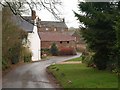
Farms in Lydeard St Lawrence
The lane leading out of the village towards Rich's Holford drops past Forge House to the farm buildings at Reed's Court and Knight's Farm.
Image: © Derek Harper
Taken: 14 Dec 2009
0.01 miles

3
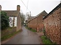
Farms in Lydeard St Lawrence (2)
Further along the lane shown in Image the C16 Reed's Court Farm is on the left http://webapp1.somerset.gov.uk/her/details.asp?prn=40417 ; Knight's Farm is on the right. Footpath T16/10 starts between the barns, though I could see no waymarking (nor indeed anywhere along it).
Image: © Derek Harper
Taken: 14 Dec 2009
0.04 miles
4
Victoria Terrace, Lydeard St Lawrence
A raised pavement runs alongside the village street as it curves down past Image which, alas, closed on 18th September 2008.
Image: © Derek Harper
Taken: 14 Dec 2009
0.10 miles
5

Victoria Terrace, Lydeard St Lawrence
Image: © Roger Cornfoot
Taken: 6 Nov 2010
0.11 miles
6
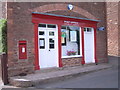
Lydeard St. Lawrence Post Office
Image: © Nick Mutton 01329 000000
Taken: 28 Jun 2008
0.11 miles
7
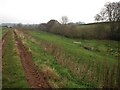
East of Lydeard St Lawrence
Footpath T16/10 follows the track along the north side of this valley east of the village, heading towards Coursley Farm.
Image: © Derek Harper
Taken: 14 Dec 2009
0.18 miles
8
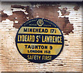
Old circular AA and Motor Union Sign in Lydeard St Lawrence
Old AA and Motor Union Sign on the wall of a garage on the west side of the road in Lydeard St Lawrence, 8 miles northwest of Taunton. Lydeard St. Lawrence parish.
This is a circular type but not quite conforming to the other two circular styles, showing distances Minehead 17½ Taunton 9 London 152.
There were five series of AA signs, mostly dating from 1923 and made by Francis & Co / Franco in Deptford, London. The village name and distance to London were usually displayed. Information on the Motor Union of Great Britain and Ireland is here https://www.gracesguide.co.uk/Motor_Union_of_Great_Britain_and_Ireland.
See also https://www.flickr.com/photos/pluralzed/4693981171 , https://www.flickr.com/photos/pluralzed/4694612760 and https://www.geograph.org.uk/photo/1707175.
Milestone Society National ID: SO-LYDSTL
Image: © Milestone Society
Taken: Unknown
0.18 miles
9
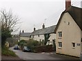
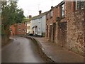
Lydeard St Lawrence
The main village street. The row of cottages on the right was, originally, a C16 farmhouse http://webapp1.somerset.gov.uk/her/details.asp?prn=17475 .
Image: © Derek Harper
Taken: 14 Dec 2009
0.19 miles