IMAGES TAKEN NEAR TO
Halse, TAUNTON, TA4 3JL
Introduction
This page details the photographs taken nearby to TA4 3JL by members of the Geograph project.
The Geograph project started in 2005 with the aim of publishing, organising and preserving representative images for every square kilometre of Great Britain, Ireland and the Isle of Man.

There are currently over 7.5m images from over14,400 individuals and you can help contribute to the project by visiting https://www.geograph.org.uk
Image Map
Images are licensed for reuse under creativecommons.org/licenses/by-sa/2.0
Notes
- Clicking on the map will re-center to the selected point.
- The higher the marker number, the further away the image location is from the centre of the postcode.
Image Listing (8 Images Found)
Images are licensed for reuse under creativecommons.org/licenses/by-sa/2.0
Image
Details
Distance
1
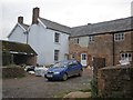
Northway Farm
The C19 farmhouse, seen from the lane approaching from Ash Priors (see also Image) is listed http://webapp1.somerset.gov.uk/her/details.asp?prn=40152 .
Image: © Derek Harper
Taken: 19 Nov 2009
0.08 miles
2
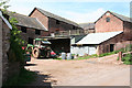
Halse: barns at Northway Farm
Looking north-north-west
Image: © Martin Bodman
Taken: 3 May 2006
0.09 miles
3
Refurbishment in progress, Northway Farm
Image: © Roger Cornfoot
Taken: 2 Apr 2014
0.09 miles
4
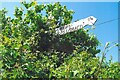
Direction Sign - Signpost at Northway Farm, Halse
Located on the southwest side of the T junction at Northway Farm at the north end of Coxland's Rock, Halse parish. 3 arms and pyramid finial.
Milestone Society National ID: SO_ST1328
Image: © J Dowding
Taken: 20 May 2023
0.09 miles
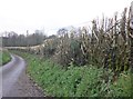
6

Coxland's Rock approaching Northway Farm
Taken from roughly the same spot as Image, close to the bridge over the Halse Water, but looking in the other direction. Northway Farm, across a gridline, also appears in Image and Image
Image: © Derek Harper
Taken: 19 Nov 2009
0.18 miles
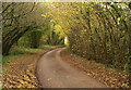
7

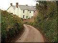
Coxland's Rock at Halse Water
Trees, mostly hazel I think, arch across the lane, seen from the bridge across the Halse Water. This lane follows the line of a Wiveliscombe Trust turnpike road.
Image: © Derek Harper
Taken: 19 Nov 2009
0.21 miles
8
Coxland's Rock near Halse Water
A view a little further round the bend shown in Image
Image: © Derek Harper
Taken: 19 Nov 2009
0.23 miles