IMAGES TAKEN NEAR TO
Silver Street, TAUNTON, TA4 2PA
Introduction
This page details the photographs taken nearby to Silver Street, TA4 2PA by members of the Geograph project.
The Geograph project started in 2005 with the aim of publishing, organising and preserving representative images for every square kilometre of Great Britain, Ireland and the Isle of Man.

There are currently over 7.5m images from over14,400 individuals and you can help contribute to the project by visiting https://www.geograph.org.uk
Image Map
Images are licensed for reuse under creativecommons.org/licenses/by-sa/2.0
Notes
- Clicking on the map will re-center to the selected point.
- The higher the marker number, the further away the image location is from the centre of the postcode.
Image Listing (171 Images Found)
Images are licensed for reuse under creativecommons.org/licenses/by-sa/2.0
Image
Details
Distance
1
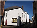
Congregational hall and school, Wiveliscombe
Jutting out into Silver Street, this building forms a pair with the Congregational church beyond; the two entrances face each other across a small yard. This building dates from 1825 http://webapp1.somerset.gov.uk/her/details.asp?prn=45083 . On the right, Silver Street continues into Golden Hill.
Image: © Derek Harper
Taken: 29 Sep 2009
0.01 miles
2
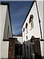
Congregational church, Wiveliscombe
The church, built in 1708, is on the right, and was enlarged in 1825 when Image on the left was built http://webapp1.somerset.gov.uk/her/details.asp?prn=45085 . The gates and gate piers are also listed http://webapp1.somerset.gov.uk/her/details.asp?prn=45084 . Seen from across Silver Street.
Image: © Derek Harper
Taken: 29 Sep 2009
0.02 miles
3

The Old Reading Rooms in Silver Street
Now a holiday letting, the reading rooms were built in 1887 and served as the Parish Council offices at first. It is made, like many other buildings in Wiveliscombe, from local Red Sandstone and Hamstone dressings, and has a mock frontage. Grade II listed.
Image: © Neil Owen
Taken: 18 Jun 2024
0.02 miles
4
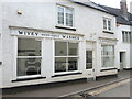
The Wivey Washer
A launderette in the town of Wiveliscombe - locally known as Wivey.
Image: © Neil Owen
Taken: 18 Jun 2024
0.02 miles
6
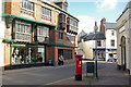
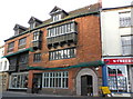
The Square, Wiveliscombe
At one time the A361 Taunton - Barnstaple road, and with it most traffic heading for North Devon, passed through this narrow street creating a notorious bottleneck. Later, traffic was diverted to the south of the town and today the bulk of it is carried by the modern A361 North Devon Link. The prominent building on the left is a Victorian flight-of-fancy, built for the Hancock family. Today, it incorporates a shop, cafe and library.
Image: © Stephen McKay
Taken: 9 Nov 2007
0.04 miles
7
Wiveliscombe: Court House
19th Century merchant's house built circa 1870 by, local brewers, the Hancock family. It has three floors and now houses a family run interiors business and library.
Image: © Mr Eugene Birchall
Taken: 15 Apr 2010
0.04 miles
8
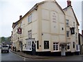
The White Hart, Wiveliscombe
Image: © Maigheach-gheal
Taken: 6 May 2010
0.04 miles
9
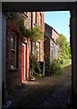
Printer's Mews, Wiveliscombe
A glimpse through an archway in the High Street in central Wiveliscombe.
Image: © Derek Harper
Taken: 29 Sep 2009
0.04 miles
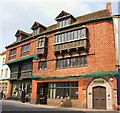
10
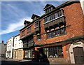
5-7 The Square Wiveliscombe
Dating from 1881, this remarkable tile-hung facade has "wooden oriels jettied out on carved grotesque corbels with hipped roofs and carved panels of decoration wooden mullioned casement windows with and without carved panels of decoration below. These panels depict stylised fruit, human figures and mythical animals in the style of the Norwegian stave church carvings" http://webapp1.somerset.gov.uk/her/details.asp?prn=45091 .
Image: © Derek Harper
Taken: 29 Sep 2009
0.04 miles