IMAGES TAKEN NEAR TO
Nightingales, TAUNTON, TA4 1JJ
Introduction
This page details the photographs taken nearby to Nightingales, TA4 1JJ by members of the Geograph project.
The Geograph project started in 2005 with the aim of publishing, organising and preserving representative images for every square kilometre of Great Britain, Ireland and the Isle of Man.

There are currently over 7.5m images from over14,400 individuals and you can help contribute to the project by visiting https://www.geograph.org.uk
Image Map
Images are licensed for reuse under creativecommons.org/licenses/by-sa/2.0
Notes
- Clicking on the map will re-center to the selected point.
- The higher the marker number, the further away the image location is from the centre of the postcode.
Image Listing (35 Images Found)
Images are licensed for reuse under creativecommons.org/licenses/by-sa/2.0
Image
Details
Distance
1
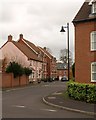
Needhams Patch, Cotford St Luke
The turning opposite Venn Close in the scene in Image The mental hospital in whose grounds the estate stands closed in 1995.
Image: © Derek Harper
Taken: 19 Nov 2009
0.07 miles
2
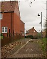
Housing at Cotford St Luke
Footpath T4/18 enters the housing development at Cotford St Luke, climbing from the flood plain of the Halse Water. The housing on the left is on Venn Close, which recalls Venn House, the house that stood here from the C15 to the C17 http://webapp1.somerset.gov.uk/her/details.asp?prn=44252 .
Image: © Derek Harper
Taken: 19 Nov 2009
0.08 miles
3
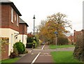
Dual use path, Cotford St Luke
Looking along the line of Graham Way, with the path taking the public footpath T4/18 through the housing estate, built in the grounds of the former Tone Vale Hospital. The crossing road is Venn Close.
Image: © Derek Harper
Taken: 19 Nov 2009
0.09 miles
5
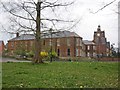
Side view, former hospital and asylum
Image: © Roger Cornfoot
Taken: 2 Apr 2014
0.10 miles
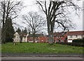
6
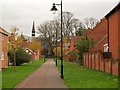
Path at Cotford St Luke
At the end on the left is the chapel of St Luke, which gives the development its name, and which is the main structure remaining from Tone Vale Hospital. "1897-98 by Giles, Gough & Trollope who also designed the hospital" http://www.imagesofengland.org.uk/Details/Default.aspx?id=361629&mode=adv , and distinguished by a flèche. Seen from Graham Way.
Image: © Derek Harper
Taken: 19 Nov 2009
0.10 miles
7
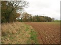
Field edge, Cotford St Luke
The Halse Water winds through the line of trees on the left. Taken from footpath T18/18 between Heathfield and Cotford St Luke.
Image: © Derek Harper
Taken: 19 Nov 2009
0.12 miles
8
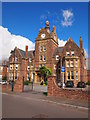
The Former Tone Vale Hospital
Originally a psychiatric hospital, now dwellings in the 'new' village of Cotford St Luke.
Image: © Chris Andrews
Taken: 2 Sep 2015
0.12 miles
9
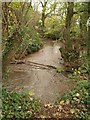
Halse Water
The muddy stream swirls along a narrow band of woodland. The stream is the parish boundary, so the footpath from which this is taken, T18/18, becomes T4/18 after crossing a bridge a few metres to the left.
Image: © Derek Harper
Taken: 19 Nov 2009
0.12 miles
10
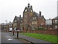
Former Lunatic asylum at Cotford St Luke
Converted to housing.
Image: © Roger Cornfoot
Taken: 2 Apr 2014
0.13 miles