IMAGES TAKEN NEAR TO
Hawkridge, DULVERTON, TA22 9QS
Introduction
This page details the photographs taken nearby to TA22 9QS by members of the Geograph project.
The Geograph project started in 2005 with the aim of publishing, organising and preserving representative images for every square kilometre of Great Britain, Ireland and the Isle of Man.

There are currently over 7.5m images from over14,400 individuals and you can help contribute to the project by visiting https://www.geograph.org.uk
Image Map (Loading...)


Getting Data...Please wait
Leaflet Map data © OpenStreetMap
Images are licensed for reuse under creativecommons.org/licenses/by-sa/2.0
Notes
- Clicking on the map will re-center to the selected point.
- The higher the marker number, the further away the image location is from the centre of the postcode.
Image Listing (20 Images Found)
Images are licensed for reuse under creativecommons.org/licenses/by-sa/2.0
Image
Details
Distance
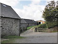
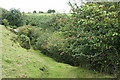
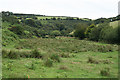
3
Withypool and Hawkridge: Cloggs Farm
Seen from the public bridleway to Shircombe Farm. A leat from a tributary of the Dane’s Brook powered a waterwheel here in the 19th century and its tail water was used to irrigate carriage gutters in the field below the farm via the farm yard. For more information see Hazel Riley and Robert Wilson North, The Field Archaeology of Exmoor. English Heritage, 2001
Image: © Martin Bodman
Taken: 22 Aug 2006
0.01 miles

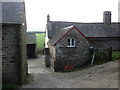
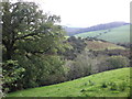
6
Withypool and Hawkridge: bridleway between Cloggs and Shircombe
Looking east-north-east, near Cloggs Farm
Image: © Martin Bodman
Taken: 22 Aug 2006
0.04 miles
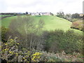
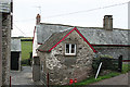
9
Withypool and Hawkridge: the Dane?s Brook valley
At Wester Shircombe. Looking south east
Image: © Martin Bodman
Taken: 22 Aug 2006
0.09 miles
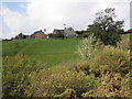
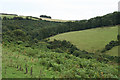
10
Withypool and Hawkridge: the Dane?s Brook valley
Seen below Shircombe, looking east-south-east
Image: © Martin Bodman
Taken: 22 Aug 2006
0.11 miles