IMAGES TAKEN NEAR TO
Brushford, DULVERTON, TA22 9AW
Introduction
This page details the photographs taken nearby to TA22 9AW by members of the Geograph project.
The Geograph project started in 2005 with the aim of publishing, organising and preserving representative images for every square kilometre of Great Britain, Ireland and the Isle of Man.

There are currently over 7.5m images from over14,400 individuals and you can help contribute to the project by visiting https://www.geograph.org.uk
Image Map
Images are licensed for reuse under creativecommons.org/licenses/by-sa/2.0
Notes
- Clicking on the map will re-center to the selected point.
- The higher the marker number, the further away the image location is from the centre of the postcode.
Image Listing (39 Images Found)
Images are licensed for reuse under creativecommons.org/licenses/by-sa/2.0
Image
Details
Distance
1
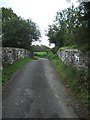
Bridge over dismantled railway line
The houses on each side of the bridge have extended their gardens over the former track.
Image: © David Smith
Taken: 21 Sep 2011
0.01 miles
3
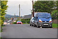
Brushford : Brushford New Road
Looking along Brushford New Road in West Somerset.
Image: © Lewis Clarke
Taken: 26 May 2014
0.05 miles
4
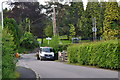
Brushford : The Green
Looking along a small road in Brushford in West Somerset.
Image: © Lewis Clarke
Taken: 26 May 2014
0.05 miles
5
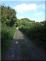
Part of former route of Exe Valley Way
The Exe Valley Way was officially rerouted away from this farm track in 2011; however, the OS map continues to show this as the route, and the signing is deficient (which is why the photographer found himself here).
Image: © David Smith
Taken: 21 Sep 2011
0.08 miles
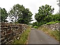
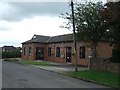
7
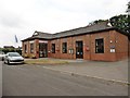
Brushford : Brushford Parish Hall
The parish hall in the village of Brushford.
Image: © Lewis Clarke
Taken: 26 May 2014
0.08 miles
8
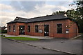
Trackbed of former Taunton to Barnstaple Railway
Image: © Roger Cornfoot
Taken: 24 Sep 2018
0.08 miles
10
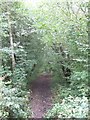
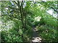
Path along the abandoned railway west of Brushford
The track is on an overgrown embankment.
Image: © David Smith
Taken: 21 Sep 2011
0.10 miles