IMAGES TAKEN NEAR TO
Winsham, CHARD, TA20 4EG
Introduction
This page details the photographs taken nearby to TA20 4EG by members of the Geograph project.
The Geograph project started in 2005 with the aim of publishing, organising and preserving representative images for every square kilometre of Great Britain, Ireland and the Isle of Man.

There are currently over 7.5m images from over14,400 individuals and you can help contribute to the project by visiting https://www.geograph.org.uk
Image Map
Images are licensed for reuse under creativecommons.org/licenses/by-sa/2.0
Notes
- Clicking on the map will re-center to the selected point.
- The higher the marker number, the further away the image location is from the centre of the postcode.
Image Listing (8 Images Found)
Images are licensed for reuse under creativecommons.org/licenses/by-sa/2.0
Image
Details
Distance
1
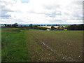
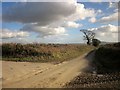
Above Hall Barn Farm
The farm can be seen in the centre of the picture.
Image: © Jonathan Thacker
Taken: 15 Sep 2017
0.02 miles
4
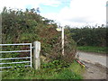
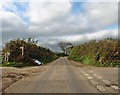
Staker's Cross
Chard Lane, ahead, carries, for about 250 metres further, the parish boundary between Wayford and West Crewkerne (left). Staker's Cross Lane (left) heads for Woolminstone. Both lanes drop steeply towards the Axe and its tributaries.
Image: © Derek Harper
Taken: 24 Feb 2015
0.22 miles
6
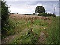
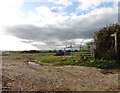
Field near Hill Barn Farm
Taken from the lane between Winsham and the A30 on St Rayn Hill, looking along the line of a field boundary, with scattered hedgerow trees on chalk upland.
Image: © Derek Harper
Taken: 28 Jul 2007
0.22 miles
7
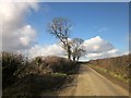
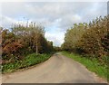
Chard Lane
Followed by the parish boundary between Wayford and West Crewkerne (right).
Image: © Derek Harper
Taken: 24 Feb 2015
0.23 miles