IMAGES TAKEN NEAR TO
Buckland St. Mary, CHARD, TA20 3QZ
Introduction
This page details the photographs taken nearby to TA20 3QZ by members of the Geograph project.
The Geograph project started in 2005 with the aim of publishing, organising and preserving representative images for every square kilometre of Great Britain, Ireland and the Isle of Man.

There are currently over 7.5m images from over14,400 individuals and you can help contribute to the project by visiting https://www.geograph.org.uk
Image Map
Images are licensed for reuse under creativecommons.org/licenses/by-sa/2.0
Notes
- Clicking on the map will re-center to the selected point.
- The higher the marker number, the further away the image location is from the centre of the postcode.
Image Listing (6 Images Found)
Images are licensed for reuse under creativecommons.org/licenses/by-sa/2.0
Image
Details
Distance
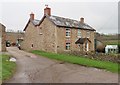
4
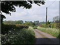
Approaching Westhay Farm
The farmhouse's roof and chimneys can be glimpsed. The lanesides are smothered with cow parsley. Taken from beneath a sycamore at the junction with Farm Lane.
Image: © Derek Harper
Taken: 7 May 2011
0.17 miles
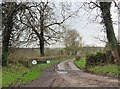
5
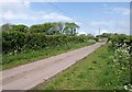
Farm Lane
Climbing steadily between verges and hedges, and trees along the next field boundary. Cow parsley is out.
Image: © Derek Harper
Taken: 7 May 2011
0.23 miles