IMAGES TAKEN NEAR TO
Buckland St. Mary, CHARD, TA20 3QE
Introduction
This page details the photographs taken nearby to TA20 3QE by members of the Geograph project.
The Geograph project started in 2005 with the aim of publishing, organising and preserving representative images for every square kilometre of Great Britain, Ireland and the Isle of Man.

There are currently over 7.5m images from over14,400 individuals and you can help contribute to the project by visiting https://www.geograph.org.uk
Image Map
Images are licensed for reuse under creativecommons.org/licenses/by-sa/2.0
Notes
- Clicking on the map will re-center to the selected point.
- The higher the marker number, the further away the image location is from the centre of the postcode.
Image Listing (7 Images Found)
Images are licensed for reuse under creativecommons.org/licenses/by-sa/2.0
Image
Details
Distance
5
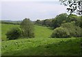
Field by Madgeon Lane
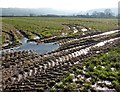
The lower part of the field shown in Image, seen from the same spot, with intermittent trees following a small tributary of the Yarty. The field is crossed by footpath CH 3/44. The wood is Suck's Rough Plot.
Image: © Derek Harper
Taken: 7 May 2011
0.21 miles
6
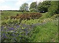
By Madgeon Lane
This is roughly the view shown in Image; the gorse seems to have increased in the last five years.
Image: © Derek Harper
Taken: 7 May 2011
0.21 miles
7
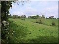
Fields by Madgeon Lane
From the same spot as Image, looking across a hillside above the Yarty valley.
Image: © Derek Harper
Taken: 7 May 2011
0.24 miles