IMAGES TAKEN NEAR TO
South Chard, CHARD, TA20 2NU
Introduction
This page details the photographs taken nearby to TA20 2NU by members of the Geograph project.
The Geograph project started in 2005 with the aim of publishing, organising and preserving representative images for every square kilometre of Great Britain, Ireland and the Isle of Man.

There are currently over 7.5m images from over14,400 individuals and you can help contribute to the project by visiting https://www.geograph.org.uk
Image Map
Images are licensed for reuse under creativecommons.org/licenses/by-sa/2.0
Notes
- Clicking on the map will re-center to the selected point.
- The higher the marker number, the further away the image location is from the centre of the postcode.
Image Listing (8 Images Found)
Images are licensed for reuse under creativecommons.org/licenses/by-sa/2.0
Image
Details
Distance
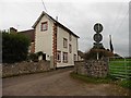
1
Stockham Farm
This old farmhouse stands just back from the Fosse Way roman road which now is the B3167 at this point.
Image: © Nigel Mykura
Taken: 31 Dec 2015
0.01 miles
3
Footpath near Stockham Farm
Looking towards gate to B3167 Fosse Way.
Image: © Peter Holmes
Taken: 18 Mar 2009
0.03 miles
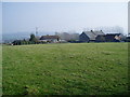
4
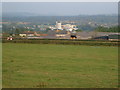
Higher Stockham Farm
A farm on the Fosse Way. Seen across a field from the A358. In the background, nearly a mile beyond, is the Dairy Crest creamery at Chard Junction.
Image: © Derek Harper
Taken: 16 Sep 2006
0.09 miles
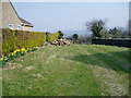
5
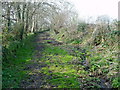
Hoskins's Lane (2)
A small stream shares this enclosed footpath.
Image: © Peter Holmes
Taken: 18 Mar 2009
0.18 miles
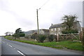
6
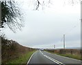
A358 junction with Stockham Lane
Stockham Lane is a narrow farm track, not suitable for heavy vehicles. There are warning signs, perhaps because Stockham Farm can be reached along the lane - but not safely.
Image: © David Smith
Taken: 30 Dec 2019
0.21 miles
7
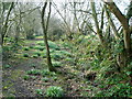
Hoskins's Lane (1)
Enclosed public footpath leading to Higher Stockham Farm on B3167.
Image: © Peter Holmes
Taken: 18 Mar 2009
0.22 miles