IMAGES TAKEN NEAR TO
Willow Drive, ILMINSTER, TA19 0FD
Introduction
This page details the photographs taken nearby to Willow Drive, TA19 0FD by members of the Geograph project.
The Geograph project started in 2005 with the aim of publishing, organising and preserving representative images for every square kilometre of Great Britain, Ireland and the Isle of Man.

There are currently over 7.5m images from over14,400 individuals and you can help contribute to the project by visiting https://www.geograph.org.uk
Image Map
Images are licensed for reuse under creativecommons.org/licenses/by-sa/2.0
Notes
- Clicking on the map will re-center to the selected point.
- The higher the marker number, the further away the image location is from the centre of the postcode.
Image Listing (12 Images Found)
Images are licensed for reuse under creativecommons.org/licenses/by-sa/2.0
Image
Details
Distance

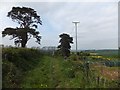
3
Public footpath north of Shepton Beauchamp
Ambling towards the Recreation Ground on the way home from a very pleasant circular Sunday morning walk. As usual, I am lagging behind my walking companions – too many photo opportunities along the way!
Image: © Kate Jewell
Taken: 11 Nov 2018
0.14 miles
4
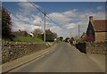
Lambrook Road, Shepton Beauchamp
Towards the eastern end of the village, with Piece Lane, shown in Image, coming up on the left.
Image: © Derek Harper
Taken: 27 Apr 2013
0.15 miles
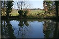
6
Footpath past allotments at Shepton Beauchamp
Image: © David Smith
Taken: 2 May 2012
0.18 miles
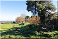
8
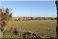
Field at Kelly's Farm, Shepton Beauchamp
From the footpath just past the north east corner of the village recreation ground.
The village in the centre distance is West Lambrook in Image
Image: © Kate Jewell
Taken: 11 Nov 2018
0.18 miles
9
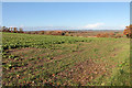
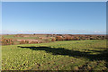
Field between Shell's Farm and Kelly's Farm, Shepton Beauchamp
On the high ground to the north of the village this large, open field is down to a cover crop of turnips.
This is a useful, quick germinating, crop helping to prevent soil compaction that can occur in the sandy silt-like loam soil in this area. The plants break up the soil while they are in the ground, like a natural plough. Turnips are an excellent cover crop for farmers who graze livestock on their fields after the main cereal harvest.
The lower lying land in the far distance is West Moor and the River Isle valley. Beyond the hills on the far horizon are the Somerset Levels.
Image: © Kate Jewell
Taken: 11 Nov 2018
0.20 miles
10
Field to the north of Shepton Beauchamp
The footpath from the top of Lincolm Hill to Brimgrove Lane crosses a large open field which backs onto the village Recreation Ground. This season it is down to turnips. See the photograph looking in the opposite direction, Image, for information about this useful cover crop.
The large oak tree in the middle distance can be seen here Image and the village beyond is West Lambrook in Image
Image: © Kate Jewell
Taken: 11 Nov 2018
0.21 miles