IMAGES TAKEN NEAR TO
The Crescent, ILMINSTER, TA19 0ER
Introduction
This page details the photographs taken nearby to The Crescent, TA19 0ER by members of the Geograph project.
The Geograph project started in 2005 with the aim of publishing, organising and preserving representative images for every square kilometre of Great Britain, Ireland and the Isle of Man.

There are currently over 7.5m images from over14,400 individuals and you can help contribute to the project by visiting https://www.geograph.org.uk
Image Map (Loading...)


Getting Data...Please wait
Leaflet Map data © OpenStreetMap
Images are licensed for reuse under creativecommons.org/licenses/by-sa/2.0
Notes
- Clicking on the map will re-center to the selected point.
- The higher the marker number, the further away the image location is from the centre of the postcode.
Image Listing (9 Images Found)
Images are licensed for reuse under creativecommons.org/licenses/by-sa/2.0
Image
Details
Distance
1
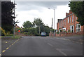
Junctions on Lister's Hill
The southern part of Ilminster.
Image: © J.Hannan-Briggs
Taken: 3 Aug 2014
0.06 miles
2

Housing south of Ilminster
Heron Way, with Little Lester the cul-de-sac leading off it. Housing dating from the late 1990s.
Image: © Derek Harper
Taken: 22 Apr 2006
0.10 miles
3
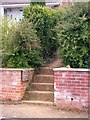
Path steps south of Ilminster
Footpath CH 32/12 leaves Long Close by these steps. The wooden notice announces a public footpath to Moolham, and a permissive path to Pretwood Hill.
Image: © Derek Harper
Taken: 22 Apr 2006
0.11 miles
4
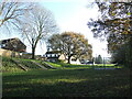
West Crescent park
A narrow corridor marks the edge of town and hosts a little play area for the children. The steep slope is actually part of the old Chard Canal and there was a short tunnel in this section.
Image: © Neil Owen
Taken: 9 Dec 2022
0.13 miles
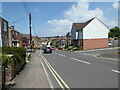
6
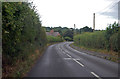
Listers Hill approaching Moolham Lane junction
The junction is hidden by the hedge in front of the house.
Image: © J.Hannan-Briggs
Taken: 3 Aug 2014
0.15 miles
7
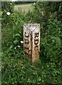
Old Boundary Marker on Moolham Lane, Ilminster
Municipal Boundary Marker on the east side of the T junction at the west end of Moolham Lane. Ilminster Urban District was created in 1899 and this post marks the boundary of Ilminster parish and Urban District and Ilminster Without parish in Chard Rural District. Now entirely in Ilminster parish.
Milestone Society National ID: SO_IMCH01pb
Image: © A Rosevear
Taken: 29 Aug 2009
0.16 miles
8
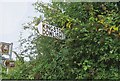
Old Direction Sign - Signpost on the junction of Listers Hill and Moolham Lane
Pyramid finial - 1 arm; Somerset SCC pyramid by the UC road, in parish of Ilminster (South Somerset District), on the west side of the T junction of Listers Hill and Moolham Lane.
surveyed
Milestone Society National ID: SO_ST3513
Image: © J Dowding
Taken: Unknown
0.16 miles
9

The New Buildings, Dowlish Ford
The 'New Buildings' comprise a row of cottages which face onto an access lane which runs from left to right on the photograph. Moolham Lane was constructed at a later date and therefore provides access to the rear of the cottages.
Image: © Len Williams
Taken: 25 Jun 2012
0.20 miles