IMAGES TAKEN NEAR TO
Haselbury Plucknett, CREWKERNE, TA18 7BF
Introduction
This page details the photographs taken nearby to TA18 7BF by members of the Geograph project.
The Geograph project started in 2005 with the aim of publishing, organising and preserving representative images for every square kilometre of Great Britain, Ireland and the Isle of Man.

There are currently over 7.5m images from over14,400 individuals and you can help contribute to the project by visiting https://www.geograph.org.uk
Image Map
Images are licensed for reuse under creativecommons.org/licenses/by-sa/2.0
Notes
- Clicking on the map will re-center to the selected point.
- The higher the marker number, the further away the image location is from the centre of the postcode.
Image Listing (11 Images Found)
Images are licensed for reuse under creativecommons.org/licenses/by-sa/2.0
Image
Details
Distance
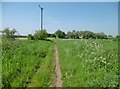
2
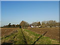
Green Lane
This field boundary/track was probably once the main access track to Rushy Wood Farm from the Puddletown area of Haselbury. When the new road was built it became redundant.
Image: © Nigel Mykura
Taken: 3 Dec 2014
0.04 miles
3
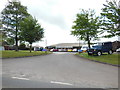
Haselbury Business Park
Off A30. The principal business seems to be for vehicle recovery.
Image: © Mike Faherty
Taken: 19 May 2018
0.04 miles
5
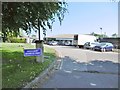
Haselbury Plucknett, track
From Puddletown to Haselbury Business Park.
Image: © Mike Faherty
Taken: 19 May 2018
0.09 miles
6
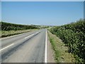
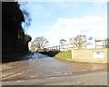
Haselbury Plucknett, A30
This section, from Crewkerne to Yeovil.
Image: © Mike Faherty
Taken: 19 May 2018
0.10 miles
7
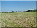
Haselbury Plucknett, footpath somewhere
From A30 to the village. The sign on A30 is fallen, stile overgrown, and no sign of a path across the mown field; despite being on a named route (Liberty Trail).
Image: © Mike Faherty
Taken: 19 May 2018
0.11 miles
8
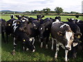
Excitable bullocks
The Liberty Trail crosses the field which contains these frisky bullocks. I am taking the photo from the other side of an electric fence. The hedge in the background hides the A30, and in the distance is Haselbury Plucknett.
Image: © Derek Harper
Taken: 30 Aug 2007
0.13 miles
9
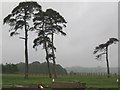
Scots Pines and rainstorms
The sky is heavy with rain but still these pinetrees are an impressive sight.
Image: © Sarah Smith
Taken: 12 Jun 2011
0.17 miles
10
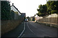
Small Lane
This narrow lane in between housing developments leads to the village recreation ground and football pitch
Image: © Nigel Mykura
Taken: 3 Dec 2014
0.20 miles