IMAGES TAKEN NEAR TO
South Street, MONTACUTE, TA15 6XD
Introduction
This page details the photographs taken nearby to South Street, TA15 6XD by members of the Geograph project.
The Geograph project started in 2005 with the aim of publishing, organising and preserving representative images for every square kilometre of Great Britain, Ireland and the Isle of Man.

There are currently over 7.5m images from over14,400 individuals and you can help contribute to the project by visiting https://www.geograph.org.uk
Image Map
Images are licensed for reuse under creativecommons.org/licenses/by-sa/2.0
Notes
- Clicking on the map will re-center to the selected point.
- The higher the marker number, the further away the image location is from the centre of the postcode.
Image Listing (296 Images Found)
Images are licensed for reuse under creativecommons.org/licenses/by-sa/2.0
Image
Details
Distance

2
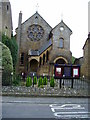
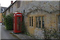
Montacute Baptist Church
The external arched stairway to the west gallery is an interesting feature www.cy-ic.com/geard/chapter_10-11/chapter_10-11.html
Image: © Peter Holmes
Taken: 22 Oct 2007
0.03 miles
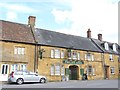
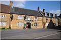
3
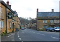
Phelips Arms Montacute
This pub is located on the Borough, the small square at the centre of the village. Phelips is the name of the family most closely associated with Montacute House. All the old buildings are built of the golden yellow hamstone which is somersets finest building stone. the stone is an oolitic limestone that comes from the Ham Hill quarries just next to the village. The name Montacute come from Mons Acutis (pointed hill) referring to St Michaels hill also next to the village.
Image: © Nigel Mykura
Taken: 5 Feb 2010
0.03 miles
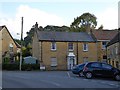
8
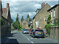
Phelips Arms, Montacute
There is an Ordnance Survey benchmark on this pub. For photo, see Image
Image: © Becky Williamson
Taken: 22 May 2015
0.03 miles
9
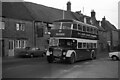
Hutchings & Cornelius bus passing the Phelips Arms, Montacute ? 1971
H&C was a small family run bus company based at South Petherton, their main service being between that village and Yeovil. 633BYA is seen on that service passing through Montacute with the 18th century Phelips Arms in the background – compare with https://www.geograph.org.uk/photo/709295 (without bus!). Relatively unusually for a small company, this bus was bought new, in 1958. It is a Dennis Loline with East Lancs body, and was one of only three Lolines to be bought by small independent operators.
This is one of a series of views featuring buses in the 60s, 70s, and 80s. http://www.geograph.org.uk/search.php?i=137652761
Image: © Alan Murray-Rust
Taken: 18 Feb 1972
0.03 miles
10
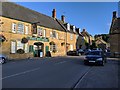
Phelips Arms, Montacute
The Phelips Arms is named after the owners of nearby Montacute House until the early twentieth century.
Image: © Philip Halling
Taken: 14 Apr 2014
0.03 miles