IMAGES TAKEN NEAR TO
Shuttern, TAUNTON, TA1 4ET
Introduction
This page details the photographs taken nearby to Shuttern, TA1 4ET by members of the Geograph project.
The Geograph project started in 2005 with the aim of publishing, organising and preserving representative images for every square kilometre of Great Britain, Ireland and the Isle of Man.

There are currently over 7.5m images from over14,400 individuals and you can help contribute to the project by visiting https://www.geograph.org.uk
Image Map (Loading...)


Getting Data...Please wait
Leaflet Map data © OpenStreetMap
Images are licensed for reuse under creativecommons.org/licenses/by-sa/2.0
Notes
- Clicking on the map will re-center to the selected point.
- The higher the marker number, the further away the image location is from the centre of the postcode.
Image Listing (303 Images Found)
Images are licensed for reuse under creativecommons.org/licenses/by-sa/2.0
Image
Details
Distance
2
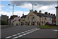
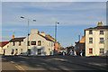
The Westgate Inn, Taunton
This pub is at the top end of Compass Hill on the corner of Westgate Street. You can see County Hall to the left of the photo, one of Taunton's Tallest Buildings.
Image: © Adrian Boliston
Taken: 28 May 2007
0.01 miles
3
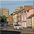
Taunton: traffic on the A38
A view along Upper High Street on a fine June evening.
Image: © John Sutton
Taken: 14 Jun 2015
0.01 miles
4
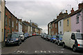
Taunton: Burton Place
Looking from the corner of Westgate Street towards the Victorian Gothic Crown Court on the other side of Upper High Street.
Image: © John Sutton
Taken: 14 Jun 2015
0.02 miles
5
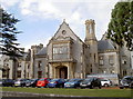
County Hall, Taunton
The distinctive form of the Shire Hall in Taunton, a Gothic work by W.B. Moffat and created in 1855-58 for around £28,000. Grade II listed, it is home to much of the administrative work of the county and the Crown Courts.
Image: © Neil Owen
Taken: 8 Oct 2014
0.04 miles
6
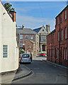
Taunton: up Compass Hill
Looking towards Westgate Street on a sunny June evening.
Image: © John Sutton
Taken: 14 Jun 2015
0.04 miles
7
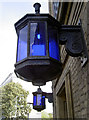
The blue lights
Some traditional furniture outside Taunton Police Station - with some low wattage lamps!
Image: © Neil Owen
Taken: 8 Oct 2014
0.04 miles
9
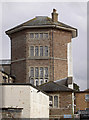
An octagonal tower
This prominent and foreboding tower holds much history - as well as inmates. It was the old County Gaol, the first incarnation of which was built in 1754, with later extensions in the following century. In the later 1800s there were sixteen executions, some of which were carried out on the roof and drawing crowds of up to 8,000 onlookers. Such practices and the role of the prison ceased around the turn of the century.
In 1908, the Somersetshire Constabulary moved into the old gaol and made a few alterations; they remain here to the present day.
The old gaol was also used in the early 1900s as a drill hall, with the West Somerset Yeomanry, Prince Albert’s Somersetshire Light Infantry and Somerset Royal Horse Artillery all being stationed here.
See http://www.geograph.org.uk/article/WW1-Great-War-Centenary---Drill-Halls.
Image: © Neil Owen
Taken: 8 Oct 2014
0.04 miles
10
Taunton: Westgate Street
Looking up the hill from Burton Place on a summer morning.
Image: © John Sutton
Taken: 14 Jun 2015
0.04 miles