An octagonal tower
Introduction
The photograph on this page of An octagonal tower by Neil Owen as part of the Geograph project.
The Geograph project started in 2005 with the aim of publishing, organising and preserving representative images for every square kilometre of Great Britain, Ireland and the Isle of Man.

There are currently over 7.5m images from over 14,400 individuals and you can help contribute to the project by visiting https://www.geograph.org.uk
An octagonal tower
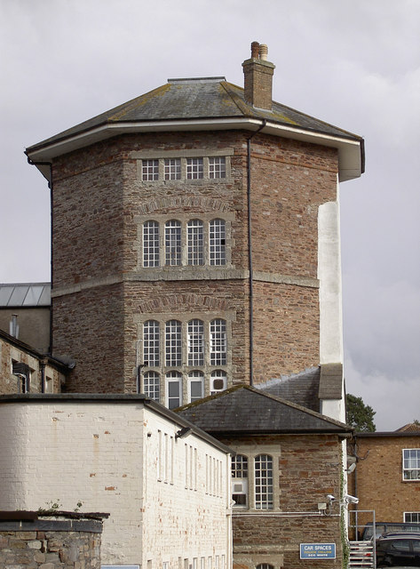
Image: © Neil Owen Taken: 8 Oct 2014
This prominent and foreboding tower holds much history - as well as inmates. It was the old County Gaol, the first incarnation of which was built in 1754, with later extensions in the following century. In the later 1800s there were sixteen executions, some of which were carried out on the roof and drawing crowds of up to 8,000 onlookers. Such practices and the role of the prison ceased around the turn of the century. In 1908, the Somersetshire Constabulary moved into the old gaol and made a few alterations; they remain here to the present day. The old gaol was also used in the early 1900s as a drill hall, with the West Somerset Yeomanry, Prince Albert’s Somersetshire Light Infantry and Somerset Royal Horse Artillery all being stationed here. See http://www.geograph.org.uk/article/WW1-Great-War-Centenary---Drill-Halls.
Images are licensed for reuse under creativecommons.org/licenses/by-sa/2.0
Image Location


Leaflet Map data © OpenStreetMap
Latitude
51.011926
Longitude
-3.10739