IMAGES TAKEN NEAR TO
Hele Lane, SOUTH PETHERTON, TA13 5DY
Introduction
This page details the photographs taken nearby to Hele Lane, TA13 5DY by members of the Geograph project.
The Geograph project started in 2005 with the aim of publishing, organising and preserving representative images for every square kilometre of Great Britain, Ireland and the Isle of Man.

There are currently over 7.5m images from over14,400 individuals and you can help contribute to the project by visiting https://www.geograph.org.uk
Image Map
Images are licensed for reuse under creativecommons.org/licenses/by-sa/2.0
Notes
- Clicking on the map will re-center to the selected point.
- The higher the marker number, the further away the image location is from the centre of the postcode.
Image Listing (141 Images Found)
Images are licensed for reuse under creativecommons.org/licenses/by-sa/2.0
Image
Details
Distance
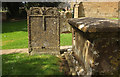
1
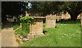
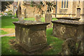
Monuments, South Petherton
In the churchyard of St Peter and St Paul's church, these are two of the three items described together at https://historicengland.org.uk/listing/the-list/list-entry/1056923 . The C18 chest tomb is much covered in ivy. The C18 headstone has "3 semi-circular-arched panels merging into each other, framing 2 angel heads and a central hour-glass".
Image: © Derek Harper
Taken: 27 Apr 2019
0.07 miles
2
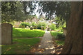
Churchyard, South Petherton
The churchyard of St Peter and St Paul's church, looking down a path that leads onto Hele Lane past the monuments shown in Image
Image: © Derek Harper
Taken: 27 Apr 2019
0.07 miles
3
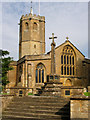
Church of St Peter and St Paul, South Petherton
Image: © Ken Grainger
Taken: 15 Sep 2006
0.07 miles
4
St James Street, South Petherton
And the Brewer's Arms pub
Image: © Ken Grainger
Taken: 15 Sep 2006
0.08 miles
5
St James' Street, South Petherton
The blue double doors lead to the infants' school.
Image: © Bill Harrison
Taken: 15 Jul 2016
0.08 miles
6
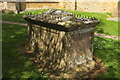
Harding monument, South Petherton
"Chest tomb. Circa 1700, adapted in early C19. Ham stone. ... heavy shallow-hipped top with rounded leading edges, with wrought-iron spikes set in all round" https://historicengland.org.uk/listing/the-list/list-entry/1294826 . In the churchyard of St Peter and St Paul's - the church is visible in the background.
Image: © Derek Harper
Taken: 27 Apr 2019
0.08 miles
7
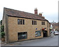
South Petherton Library...
...and tourist information centre. I'm not totally convinced by the 'crazy paving' effect of the stonework.
Image: © Bill Harrison
Taken: 15 Jul 2016
0.08 miles
8
Monuments, South Petherton
A tomb chest and headstone just south of the Church of St Peter and St Paul. These are two of the monuments described at https://historicengland.org.uk/listing/the-list/list-entry/1056961 . The headstone has an "almost flat top with 2 semi-circular panels framing angel heads, with hourglass between and scrolls to sides; frame to panel has curved scroll decoration and central half-drop." The chest tomb is the first of the four items described.
Image: © Derek Harper
Taken: 27 Apr 2019
0.08 miles
9
Monuments, South Petherton
The group of four monouenmts descrined together at https://historicengland.org.uk/listing/the-list/list-entry/1056961 . The further chest tomb and headstone are more clearly seen at Image The nearest tomb chest must be to "Thomas Viles, died 1783".
Image: © Derek Harper
Taken: 27 Apr 2019
0.08 miles
10
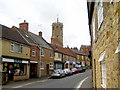
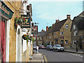
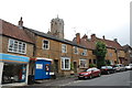
St James Street - South Petherton
Looking up the street the octagonal tower of the Church of St Peter and St Paul looms over the roofs of the terraced shops.
Image: © Sarah Smith
Taken: 3 Oct 2009
0.08 miles