IMAGES TAKEN NEAR TO
Parmin Way, TAUNTON, TA1 2JU
Introduction
This page details the photographs taken nearby to Parmin Way, TA1 2JU by members of the Geograph project.
The Geograph project started in 2005 with the aim of publishing, organising and preserving representative images for every square kilometre of Great Britain, Ireland and the Isle of Man.

There are currently over 7.5m images from over14,400 individuals and you can help contribute to the project by visiting https://www.geograph.org.uk
Image Map
Images are licensed for reuse under creativecommons.org/licenses/by-sa/2.0
Notes
- Clicking on the map will re-center to the selected point.
- The higher the marker number, the further away the image location is from the centre of the postcode.
Image Listing (8 Images Found)
Images are licensed for reuse under creativecommons.org/licenses/by-sa/2.0
Image
Details
Distance
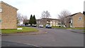
2
Path by Holway Park Community Primary School
From the end of Shakespeare Avenue, with the school grounds behind the blue fence on the right, and houses on one of Normandy Drive's cul-de-sacs on the left.
Image: © Derek Harper
Taken: 11 Mar 2006
0.15 miles
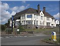
4
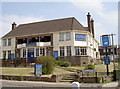
The Flying Horse
A large public house, looking like an inter-war development along with the local area.
Image: © Neil Owen
Taken: 16 Jul 2013
0.17 miles
5
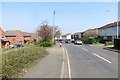
Normandy Drive, Taunton
A curving road that forms a crescent off Lisieux Way, and which has several cul-de-sacs which are also addressed Normandy Drive.
Image: © Derek Harper
Taken: 11 Mar 2006
0.17 miles
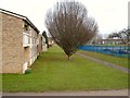
6
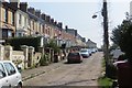
Lane off Holway Drive
Around the back of a row of terraces which stand out amongst the modern suburbs to the north.
Image: © Richard Webb
Taken: 9 Apr 2015
0.20 miles
7
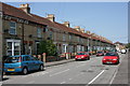
Eastleigh Road - Taunton
The only place in Taunton to suffer bomb damage in The Second World War.
Image: © Nick Chipchase
Taken: 11 May 2009
0.23 miles
8

Taunton Fire Station
Taunton Fire Station, Liseux Way, Taunton, Somerset. Up until this year, the counties of Somerset & neighbouring Devon ran their own fire services. On 1st April 2007, the two counties combined fire services to form the Devon & Somerset Fire & Rescue Service. All other parts of the respective county councils' functions remain administered by the relevant county.
Image: © Kevin Hale
Taken: 29 Apr 2007
0.23 miles