IMAGES TAKEN NEAR TO
Kingsbury Episcopi, MARTOCK, TA12 6BY
Introduction
This page details the photographs taken nearby to TA12 6BY by members of the Geograph project.
The Geograph project started in 2005 with the aim of publishing, organising and preserving representative images for every square kilometre of Great Britain, Ireland and the Isle of Man.

There are currently over 7.5m images from over14,400 individuals and you can help contribute to the project by visiting https://www.geograph.org.uk
Image Map
Images are licensed for reuse under creativecommons.org/licenses/by-sa/2.0
Notes
- Clicking on the map will re-center to the selected point.
- The higher the marker number, the further away the image location is from the centre of the postcode.
Image Listing (17 Images Found)
Images are licensed for reuse under creativecommons.org/licenses/by-sa/2.0
Image
Details
Distance
2
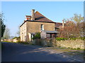
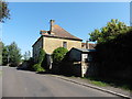
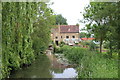
Gawbridge Mill House
This substantial ham Stone house would have belonged to the miller when the mill was a thriving concern.
Image: © Nigel Mykura
Taken: 2 May 2013
0.00 miles
4
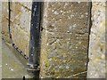
Benchmark on Gawbridge Mill
Ordnance Survey benchmark, described on database at http://www.bench-marks.org.uk/bm67271.
Image: © Becky Williamson
Taken: 2 Jun 2015
0.02 miles
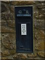
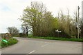
6
Old Direction Sign - Signpost by Gawbridge Bow, Kingsbury Episcopi Parish
Lost finial - 3 arms; Somerset SCC modern by the UC road, in parish of Kingsbury Episcopi (South Somerset District), Gawbridge Bow, junction of Broadmead and Hawthorn Hill.
Surveyed
Milestone Society National ID: SO_ST4419
Image: © Milestone Society
Taken: Unknown
0.14 miles

8
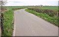
Road to Coat
From the bridge over the Parrett at Gawbridge Bow. The River Parrett Trail leaves the road to the right here - see Image On the left is a footpath sign pointing along footpath Y 16/28, which follows the river downstream on the other bank from the Trail.
Image: © Derek Harper
Taken: 16 Apr 2016
0.15 miles
9
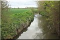
River Parrett at Gawbridge Bow
Looking upstream from the bridge from which Image] looks downstream. The River Parrett Trail follows footpath Y 16/11 along the right bank - the left one visually here.
Image: © Derek Harper
Taken: 16 Apr 2016
0.15 miles
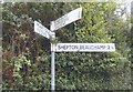
10
Junction at Gawbridge Bow
Close to the point where Image was taken, behind the camera. The two LDPs diverge here; the River Parrett Trail turns left and almost immediately right once across the river, while the Macmillan Way Link turns right along the road for a while.
Image: © Derek Harper
Taken: 16 Apr 2016
0.15 miles