IMAGES TAKEN NEAR TO
Staplegrove Road, TAUNTON, TA1 1DG
Introduction
This page details the photographs taken nearby to Staplegrove Road, TA1 1DG by members of the Geograph project.
The Geograph project started in 2005 with the aim of publishing, organising and preserving representative images for every square kilometre of Great Britain, Ireland and the Isle of Man.

There are currently over 7.5m images from over14,400 individuals and you can help contribute to the project by visiting https://www.geograph.org.uk
Image Map
Images are licensed for reuse under creativecommons.org/licenses/by-sa/2.0
Notes
- Clicking on the map will re-center to the selected point.
- The higher the marker number, the further away the image location is from the centre of the postcode.
Image Listing (128 Images Found)
Images are licensed for reuse under creativecommons.org/licenses/by-sa/2.0
Image
Details
Distance
2
Trees in The Avenue, Taunton
Viewed across the A3027 Staplegrove Road.
Image: © Jaggery
Taken: 11 Sep 2012
0.05 miles
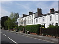
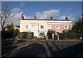
3
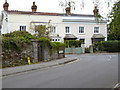
Houses, Staplegrove Road, Taunton
A little way east (towards the town) from Image, the bay-fronted house makes an impressive end to a terrace facing Staplegrove Road, the main road leading northwestwards out of Taunton. The side road is Linden Grove.
Image: © Derek Harper
Taken: 24 Jan 2009
0.06 miles
4
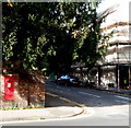
Edward VII postbox in Taunton
On the corner of Staplegrove Road and Linden Grove. The monogram on the box dates it to the reign of King Edward VII (1901-1910).
Image: © Jaggery
Taken: 11 Sep 2012
0.07 miles
5
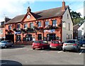
The Kings Arms, Taunton
The pub at 22 Staplegrove Road is set back 20 metres from the road.
Image: © Jaggery
Taken: 11 Sep 2012
0.08 miles
6
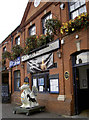
The Kings Arms
Outside is a friendly-looking wyvern, name of King George.
Image: © Neil Owen
Taken: 30 Oct 2014
0.08 miles
7
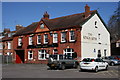
The Kings Arms - Taunton
This is situated on Staplegrove Road.
Image: © Nick Chipchase
Taken: 13 Apr 2009
0.09 miles
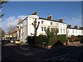
8
Houses on Staplegrove Road, Taunton
An elegant pair of houses opposite the junction with French Weir Avenue.
Image: © Derek Harper
Taken: 24 Jan 2009
0.09 miles
9
Junction of French Weir Avenue and Staplegrove Road
The houses have changed colour in the previous six years - see http://www.geograph.org.uk/photo/1138865.
Image: © Shazz
Taken: 26 Apr 2015
0.09 miles
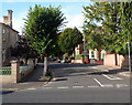
10
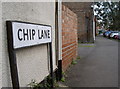
Chip Lane
One of Taunton's old lanes remains part of the present. The lane reaches to the junction of Staplegrove Road and Station Road. There is also a flush bracket here on the side wall after the entrance - see Image
Image: © Neil Owen
Taken: 30 Oct 2014
0.10 miles