IMAGES TAKEN NEAR TO
Weirfield Green, TAUNTON, TA1 1AZ
Introduction
This page details the photographs taken nearby to Weirfield Green, TA1 1AZ by members of the Geograph project.
The Geograph project started in 2005 with the aim of publishing, organising and preserving representative images for every square kilometre of Great Britain, Ireland and the Isle of Man.

There are currently over 7.5m images from over14,400 individuals and you can help contribute to the project by visiting https://www.geograph.org.uk
Image Map
Images are licensed for reuse under creativecommons.org/licenses/by-sa/2.0
Notes
- Clicking on the map will re-center to the selected point.
- The higher the marker number, the further away the image location is from the centre of the postcode.
Image Listing (55 Images Found)
Images are licensed for reuse under creativecommons.org/licenses/by-sa/2.0
Image
Details
Distance
1
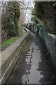
Roughmoor path, Taunton.
Leads to Weirfield Nature Reserve and path along River Tone.
Image: © Nick Chipchase
Taken: 9 Mar 2009
0.06 miles
2
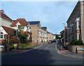
White Willows Gardens, Taunton
A cul-de-sac on the east side of Staplegrove Road.
Image: © Jaggery
Taken: 11 Sep 2012
0.09 miles
3
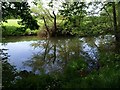
River Tone
From the West Deane Way, which follows Taunton footpath 3/6 along the left bank of the tree-lined river for about 600 metres across this square.
Image: © Derek Harper
Taken: 10 May 2008
0.10 miles
4
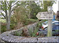
The Two Counties Way
The Two Counties Way Long Distance Path largely follows the Grand Western Canal as it connects Taunton to the Mouth of the River Exe, some 56 miles (90km).
Image: © Neil Owen
Taken: 30 Oct 2014
0.11 miles
5
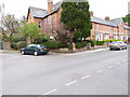
Junction of French Weir Avenue and Staplegrove Road
The houses have changed colour in the previous six years - see http://www.geograph.org.uk/photo/1138865.
Image: © Shazz
Taken: 26 Apr 2015
0.11 miles
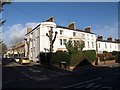
6
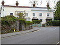
Houses on Staplegrove Road, Taunton
An elegant pair of houses opposite the junction with French Weir Avenue.
Image: © Derek Harper
Taken: 24 Jan 2009
0.11 miles
7
Junction of Northfield Road with French Weir Avenue
Image: © Shazz
Taken: 26 Apr 2015
0.12 miles
8
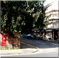
Edward VII postbox in Taunton
On the corner of Staplegrove Road and Linden Grove. The monogram on the box dates it to the reign of King Edward VII (1901-1910).
Image: © Jaggery
Taken: 11 Sep 2012
0.13 miles
9
Path by the River Tone
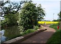
Contrasting colours by the river. The well made-up path may turn away from the riverside at this point, heading into a housing estate at Frieze Hill, but the West Deane Way follows Taunton footpath 3/6 upstream along the edge of the rape field.
Image: © Derek Harper
Taken: 10 May 2008
0.14 miles
10
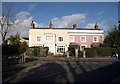
Houses, Staplegrove Road, Taunton
A little way east (towards the town) from Image, the bay-fronted house makes an impressive end to a terrace facing Staplegrove Road, the main road leading northwestwards out of Taunton. The side road is Linden Grove.
Image: © Derek Harper
Taken: 24 Jan 2009
0.14 miles