IMAGES TAKEN NEAR TO
Old School Lane, SOMERTON, TA11 7JP
Introduction
This page details the photographs taken nearby to Old School Lane, TA11 7JP by members of the Geograph project.
The Geograph project started in 2005 with the aim of publishing, organising and preserving representative images for every square kilometre of Great Britain, Ireland and the Isle of Man.

There are currently over 7.5m images from over14,400 individuals and you can help contribute to the project by visiting https://www.geograph.org.uk
Image Map
Images are licensed for reuse under creativecommons.org/licenses/by-sa/2.0
Notes
- Clicking on the map will re-center to the selected point.
- The higher the marker number, the further away the image location is from the centre of the postcode.
Image Listing (46 Images Found)
Images are licensed for reuse under creativecommons.org/licenses/by-sa/2.0
Image
Details
Distance
1
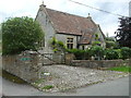
Lydford old school
The village school dates back well over a century, being founded as a National School in 1873. By 1946, the decision was made to close East Lydford school, thereby saving West Lydford. It obtained aided status in 1952 as Lydford on Fosse Primary school and served the villages until the 1980s, when pupil numbers dropped markedly. It closed finally in 1990 and is now a private residence.
Image: © Neil Owen
Taken: 10 Jul 2020
0.05 miles
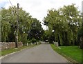
2
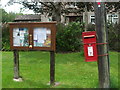
High Street, West Lydford
The communications are adorned with a little woollen trinket.
Image: © Neil Owen
Taken: 10 Jul 2020
0.05 miles
5
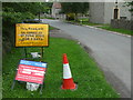
Improving the sewage network
A couple of signs tell of the work carried out recently; a sewage pumping station is just behind the camera view.
Image: © Neil Owen
Taken: 10 Jul 2020
0.11 miles
7
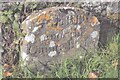
Old Boundary Marker in Lydford on Fosse
County Bridge Marker on the west side of High Street, south of the bridge on the River Brue. Lydford on Fosse parish. Inscribed HERE / ends the / County Bridge. The stone was erected in 1821 to mark the extent of roadway adjoining the bridge that the County was obliged to maintain.
Milestone Society National ID: SO_LYDFFO01br
Image: © S Melligan
Taken: Unknown
0.12 miles
8
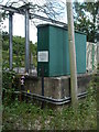
West Lydford Sewage Pumping Station
Close to the River Brue.
Image: © Neil Owen
Taken: 10 Jul 2020
0.12 miles
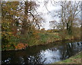
9
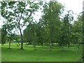
Orchard between the waters
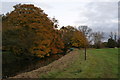
A small cluster of trees on land between the River Brue and the Mill Stream.
Image: © Neil Owen
Taken: 10 Jul 2020
0.14 miles