IMAGES TAKEN NEAR TO
Foddington, SOMERTON, TA11 7EL
Introduction
This page details the photographs taken nearby to Foddington, TA11 7EL by members of the Geograph project.
The Geograph project started in 2005 with the aim of publishing, organising and preserving representative images for every square kilometre of Great Britain, Ireland and the Isle of Man.

There are currently over 7.5m images from over14,400 individuals and you can help contribute to the project by visiting https://www.geograph.org.uk
Image Map (Loading...)


Getting Data...Please wait
Leaflet Map data © OpenStreetMap
Images are licensed for reuse under creativecommons.org/licenses/by-sa/2.0
Notes
- Clicking on the map will re-center to the selected point.
- The higher the marker number, the further away the image location is from the centre of the postcode.
Image Listing (18 Images Found)
Images are licensed for reuse under creativecommons.org/licenses/by-sa/2.0
Image
Details
Distance

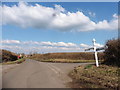
3
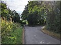
Junction for the lane to Higher Foddington
Image: © Rob Purvis
Taken: 23 Jul 2022
0.08 miles
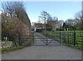
6
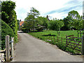
Entrance to Standerwick Farm - Foddington
Image: © Mike Searle
Taken: 22 May 2007
0.13 miles
7
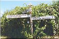
Old Direction Sign - Signpost by Perry Hill, Babcary parish
Pyramid finial - 3 arms; Somerset SCC pyramid by the UC road, in parish of Babcary (South Somerset District), Perry Hill, junction with lane to Foddington.
Surveyed
Milestone Society National ID: SO_ST5729
Image: © Milestone Society
Taken: Unknown
0.15 miles
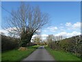
9
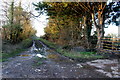
Farm Track near Higher Foddington
This short track giving access to fields also carries a footpath to Lower Foddinton .
Image: © Nigel Mykura
Taken: 26 Dec 2017
0.16 miles
10
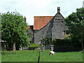
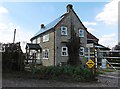
Standerwick Farmhouse - Foddington
Grade II* listed detached farmhouse dating from circa 1400 to circa 1550, with later modifications.
Image: © Mike Searle
Taken: 22 May 2007
0.16 miles