IMAGES TAKEN NEAR TO
Primrose Hill, SOMERTON, TA11 7AP
Introduction
This page details the photographs taken nearby to Primrose Hill, TA11 7AP by members of the Geograph project.
The Geograph project started in 2005 with the aim of publishing, organising and preserving representative images for every square kilometre of Great Britain, Ireland and the Isle of Man.

There are currently over 7.5m images from over14,400 individuals and you can help contribute to the project by visiting https://www.geograph.org.uk
Image Map
Images are licensed for reuse under creativecommons.org/licenses/by-sa/2.0
Notes
- Clicking on the map will re-center to the selected point.
- The higher the marker number, the further away the image location is from the centre of the postcode.
Image Listing (10 Images Found)
Images are licensed for reuse under creativecommons.org/licenses/by-sa/2.0
Image
Details
Distance
1
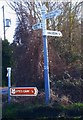
Old Direction Sign - Signpost The Charltons Parish
Pyramid finial - 3 arms; Somerset SCC pyramid by the UC road, in parish of The Charltons (South Somerset District), junction of Ilchester Road and Primrose Hill.
Surveyed
Milestone Society National ID: SO_ST5328A
Image: © Milestone Society
Taken: Unknown
0.09 miles
2
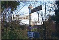
Old Direction Sign - Signpost by Ilchester Road, Charlton Mackrell
Pyramid finial - 3 arms; Somerset SCC pyramid by the UC road, in parish of Charlton Mackrell (South Somerset District), junction of Ilchester Road with Bonfire Lane.
Surveyed
Milestone Society National ID: SO_ST5328B
Image: © Milestone Society
Taken: Unknown
0.15 miles
3
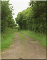
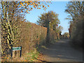
Ridgeway Lane
Bridleway 40UD022 L 6/28 approaches Tout Lane. Taken from the same spot as
Image
Image: © Derek Harper
Taken: 8 Jun 2017
0.16 miles
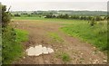
6
Charlton Adam from the railway
Houses at the west end of the village, seen from a train on the main line from Castle Cary to Taunton. Largely obscured by the branches of the tree is the church.
Image: © Derek Harper
Taken: 19 Mar 2012
0.20 miles
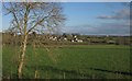
7
Farmland by Ridgeway Lane
From the bridleway a little south of Tout Lane. In the centre, beyond a couple of hedges, is Southfields.
Image: © Derek Harper
Taken: 8 Jun 2017
0.21 miles
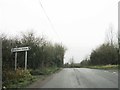
8
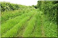
Ridgeway Lane
Bridleway 40UD022 L 6/28 runs along a wide track.
Image: © Derek Harper
Taken: 8 Jun 2017
0.22 miles
10
Charlton Adam
Charlton Adam is a rather shapeless small village that has merged with its near neighbour Charlton Mackrell. The Charlton part of their name comes from ceorl (churl) and charlton is the place where the ceorls lived. A ceorl was a freeman of the lowest rank in Anglo-Saxon England. The road is George St.
Image: © Nigel Mykura
Taken: 6 Jun 2013
0.24 miles