IMAGES TAKEN NEAR TO
Barley Croft, SOMERTON, TA11 6PW
Introduction
This page details the photographs taken nearby to Barley Croft, TA11 6PW by members of the Geograph project.
The Geograph project started in 2005 with the aim of publishing, organising and preserving representative images for every square kilometre of Great Britain, Ireland and the Isle of Man.

There are currently over 7.5m images from over14,400 individuals and you can help contribute to the project by visiting https://www.geograph.org.uk
Image Map (Loading...)


Getting Data...Please wait
Leaflet Map data © OpenStreetMap
Images are licensed for reuse under creativecommons.org/licenses/by-sa/2.0
Notes
- Clicking on the map will re-center to the selected point.
- The higher the marker number, the further away the image location is from the centre of the postcode.
Image Listing (16 Images Found)
Images are licensed for reuse under creativecommons.org/licenses/by-sa/2.0
Image
Details
Distance
1
Ricksey Park - Somerton
Park recently seeded (2021) for community use by developers of Patch Meadows Housing Estate. Trees flourish as they are next to the Mill Stream that winds its way through Somerton to join the River Cary.
Ricksey or Wrexy or Rixsey lane borders the west edge of this open space.
Image: © Barry King
Taken: 12 Apr 2021
0.10 miles
2
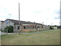
Somerton sports pavilion
As the facility grew over time, the new Clubhouse lounge bar was opened by famous Somerset C.C. cricketers Ian Botham and Viv Richards in 1985.
Image: © Neil Owen
Taken: 28 Jul 2022
0.14 miles
3
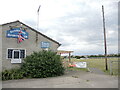
Somerton Sports Club
Situated in a large open space on Gassons Lane, the facility has lots of different activities and sports on offer. The town's recreation started in 1946 at the Memorial Field before relocation to the seven acre site here following a grant of land by a local family in 1967. Various sporting clubs and organisations have gravitated to the grounds and it is now under the auspices of a charitable trust.
Image: © Neil Owen
Taken: 28 Jul 2022
0.14 miles
4
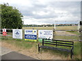
Where the town comes to play
Somerton Sports Club is home to many different clubs and sports. The site expanded with the addition of another eleven acres of land by the Mitcham family in 1992, allowing more to be enjoyed.
Image: © Neil Owen
Taken: 28 Jul 2022
0.18 miles
5
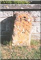
Old Milestone by the B3153, Langport Road, Somerton Parish
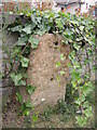
Stone post (plate lost) by the B3153, in parish of SOMERTON (SOUTH SOMERSET District), West end of Somerton, on grass verge in front of simulated stone garden wall, on North side of road. LSCC iron plate, erected by the Langport, Somerton & Castle Cary turnpike trust in the 19th century.
Inscription once read:- : (Langport 4 / Somerton ½) :
Milestone Society National ID: SO_LPSM04
Image: © JR Dowding
Taken: 9 Jan 2008
0.20 miles
6
Milestone on the Langport Road
Today the stone is missing the metalwork, but has a natty hairdo. It used to read 'Langport 4, Somerton ½'. See Image] for a wider view into town.
Image: © Neil Owen
Taken: 28 Jul 2022
0.20 miles
7
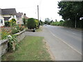
The road into Somerton
The B3153 Langport Road heads into town. At the roadside is an old milestone - see Image
Image: © Neil Owen
Taken: 28 Jul 2022
0.20 miles