IMAGES TAKEN NEAR TO
Compton Dundon, SOMERTON, TA11 6PD
Introduction
This page details the photographs taken nearby to TA11 6PD by members of the Geograph project.
The Geograph project started in 2005 with the aim of publishing, organising and preserving representative images for every square kilometre of Great Britain, Ireland and the Isle of Man.

There are currently over 7.5m images from over14,400 individuals and you can help contribute to the project by visiting https://www.geograph.org.uk
Image Map
Images are licensed for reuse under creativecommons.org/licenses/by-sa/2.0
Notes
- Clicking on the map will re-center to the selected point.
- The higher the marker number, the further away the image location is from the centre of the postcode.
Image Listing (7 Images Found)
Images are licensed for reuse under creativecommons.org/licenses/by-sa/2.0
Image
Details
Distance
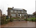
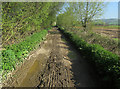
2
Upper Hayes Farm
With large supplies of animal feed.
Image: © Hugh Venables
Taken: 9 Apr 2017
0.08 miles
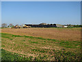
5
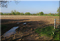
Maize stubble near Lower Hayes Farm
Being used to arable land, the amount of land used for fodder crops relative to the number of animals was noticeable.
Image: © Hugh Venables
Taken: 9 Apr 2017
0.14 miles
7
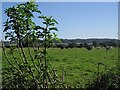
Curious cows
Cows turn from their munching to wonder why someone is leaning over the electric fence to take a picture of them.
Image: © Neville Goodman
Taken: 4 Aug 2007
0.24 miles