IMAGES TAKEN NEAR TO
Buttercup Close, SOMERTON, TA11 6DN
Introduction
This page details the photographs taken nearby to Buttercup Close, TA11 6DN by members of the Geograph project.
The Geograph project started in 2005 with the aim of publishing, organising and preserving representative images for every square kilometre of Great Britain, Ireland and the Isle of Man.

There are currently over 7.5m images from over14,400 individuals and you can help contribute to the project by visiting https://www.geograph.org.uk
Image Map
Images are licensed for reuse under creativecommons.org/licenses/by-sa/2.0
Notes
- Clicking on the map will re-center to the selected point.
- The higher the marker number, the further away the image location is from the centre of the postcode.
Image Listing (7 Images Found)
Images are licensed for reuse under creativecommons.org/licenses/by-sa/2.0
Image
Details
Distance
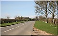
5
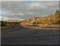
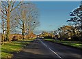
Somerton
Spring flowers along the road on the approach of the B3153 at Sommerton.
Image: © roger geach
Taken: 8 Apr 2010
0.22 miles
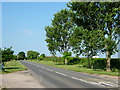
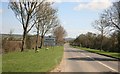
6
B3153 road nr Somerton
Looking towards Langport
Image: © roger geach
Taken: 8 Apr 2010
0.22 miles
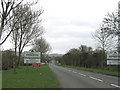
7
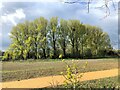
Ricksey Park - Somerton
Park recently seeded (2021) for community use by developers of Patch Meadows Housing Estate. Trees flourish as they are next to the Mill Stream that winds its way through Somerton to join the River Cary.
Ricksey or Wrexy or Rixsey lane borders the west edge of this open space.
Image: © Barry King
Taken: 12 Apr 2021
0.24 miles