IMAGES TAKEN NEAR TO
The Embankment, LANGPORT, TA10 9RZ
Introduction
This page details the photographs taken nearby to The Embankment, TA10 9RZ by members of the Geograph project.
The Geograph project started in 2005 with the aim of publishing, organising and preserving representative images for every square kilometre of Great Britain, Ireland and the Isle of Man.

There are currently over 7.5m images from over14,400 individuals and you can help contribute to the project by visiting https://www.geograph.org.uk
Image Map
Images are licensed for reuse under creativecommons.org/licenses/by-sa/2.0
Notes
- Clicking on the map will re-center to the selected point.
- The higher the marker number, the further away the image location is from the centre of the postcode.
Image Listing (85 Images Found)
Images are licensed for reuse under creativecommons.org/licenses/by-sa/2.0
Image
Details
Distance
1
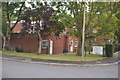
Portcullis House
Social services in this leafy corner of former council housing estate.
Image: © John M
Taken: 19 Sep 2014
0.02 miles
2
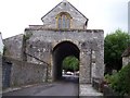
The Hanging chapel Langport
Uses have included as a Sunday School (1818-1827), Grammar School, armoury, museum, store by the local militia in the 19th century and used today as a Masonic Lodge.
It is a complete myth that any bodies were ever hanged there
Image: © Pam Goodey
Taken: 7 Jul 2008
0.11 miles
3
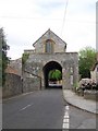
The Hanging Chapel, Langport
Gateway with chapel over. The structure has parts that are 13th century in origin but what is seen today dates mostly from the 15th century. Restoration was carried out in 19th century.
The Chantry Chapel of Blessed Virgin Mary, was mentioned in documents of 1344, it became the Town Hall in 1596-1600, Langport Grammar School 1706-c1790, then an arms store, a Sunday School, and private uses until it was leased as a Masonic Lodge in 1891. It is still used today as the Masonic Lodge.
Image: © Maigheach-gheal
Taken: 20 May 2010
0.12 miles
4
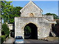
Town Gate, Langport
Now used as a Masonic Hall
Image: © Ken Grainger
Taken: 19 Jun 2006
0.12 miles
5
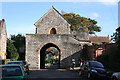
Langport: East Gate
The town was founded on Langport Hill, the pocket parish probably carved out of the bishop’s larger holding, Huish Episcopi. Langport was originally walled and the East Gate with its Hanging Chapel provide a glimpse of the medieval defences
Image: © Martin Bodman
Taken: 10 Oct 2008
0.13 miles
6

East Gate, Langport
Also known as the 'Hanging Chapel'.
Image: © Roger Cornfoot
Taken: 25 Jan 2017
0.13 miles
7
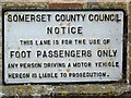
Foot Passengers Only, Langport
This sign is to be found at the start of this footpath Image
Image: © Maigheach-gheal
Taken: 20 May 2010
0.13 miles
8
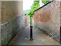
Footpath, Langport
This path drops down to the A378. There is an interesting sign at the Image
Image: © Maigheach-gheal
Taken: 20 May 2010
0.13 miles
10
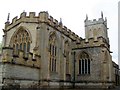
All Saints Church, Langport
The church is 12th/13th century in origin but it was mostly rebuilt in the late 15th to early 16th century. There was another period of restoration under W B Paul in 1867. It is built of local lias stone, with Ham stone dressings,
Image: © Maigheach-gheal
Taken: 20 May 2010
0.14 miles