IMAGES TAKEN NEAR TO
Parrett Close, LANGPORT, TA10 9PG
Introduction
This page details the photographs taken nearby to Parrett Close, TA10 9PG by members of the Geograph project.
The Geograph project started in 2005 with the aim of publishing, organising and preserving representative images for every square kilometre of Great Britain, Ireland and the Isle of Man.

There are currently over 7.5m images from over14,400 individuals and you can help contribute to the project by visiting https://www.geograph.org.uk
Image Map
Images are licensed for reuse under creativecommons.org/licenses/by-sa/2.0
Notes
- Clicking on the map will re-center to the selected point.
- The higher the marker number, the further away the image location is from the centre of the postcode.
Image Listing (130 Images Found)
Images are licensed for reuse under creativecommons.org/licenses/by-sa/2.0
Image
Details
Distance
2

Ceramic map of the Somerset Levels
Outside the library in Langport
Image: © Ken Grainger
Taken: 19 Jun 2006
0.03 miles
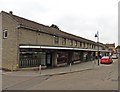
4

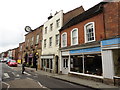
Market, Langport
Market stalls beneath the trees on the island at Parrett Close. In the background is the C18 town hall https://www.historicengland.org.uk/listing/the-list/list-entry/1056610 .
Image: © Derek Harper
Taken: 11 Aug 2018
0.03 miles
6
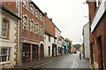
Langport: public library
In Whatley, with a view towards Cheapside
Image: © Martin Bodman
Taken: 10 Oct 2008
0.03 miles
8
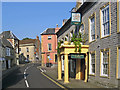
Bow Street, Langport, looking east
The Langport Arms Hotel
Image: © Ken Grainger
Taken: 19 Jun 2006
0.03 miles
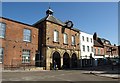
10
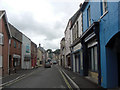
Bow Street, Langport
A series of listed buildings lines the south (left) side of the A378. First here on the immediate left is part of the Old Market House, formerly an inn https://www.historicengland.org.uk/listing/the-list/list-entry/1056639 . Cocklemoor gift and craft shop occupies Ensor House https://www.historicengland.org.uk/listing/the-list/list-entry/1264902 : "Stylistically the building could be by Nathaniel Ireson - the Hoare family of Stourhead were Lords of the Manor, and Ireson worked for the Hoare family elsewhere." After the two-storey building https://www.historicengland.org.uk/listing/the-list/list-entry/1346048 is The Angel Inn, listed as The Old Custom House Inn https://www.historicengland.org.uk/listing/the-list/list-entry/1235787 . Beyond are https://www.historicengland.org.uk/listing/the-list/list-entry/1056640 and https://www.historicengland.org.uk/listing/the-list/list-entry/1346105 .
Image: © Derek Harper
Taken: 11 Aug 2018
0.04 miles