IMAGES TAKEN NEAR TO
Langport Road, LANGPORT, TA10 9NB
Introduction
This page details the photographs taken nearby to Langport Road, TA10 9NB by members of the Geograph project.
The Geograph project started in 2005 with the aim of publishing, organising and preserving representative images for every square kilometre of Great Britain, Ireland and the Isle of Man.

There are currently over 7.5m images from over14,400 individuals and you can help contribute to the project by visiting https://www.geograph.org.uk
Image Map
Images are licensed for reuse under creativecommons.org/licenses/by-sa/2.0
Notes
- Clicking on the map will re-center to the selected point.
- The higher the marker number, the further away the image location is from the centre of the postcode.
Image Listing (10 Images Found)
Images are licensed for reuse under creativecommons.org/licenses/by-sa/2.0
Image
Details
Distance
1
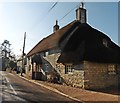
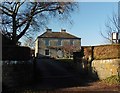
A372 north of Court House
The Grade II house can be seen beside the road and dates from the 14th C. It has English Heritage Building ID: 263243. See also: http://www.britishlistedbuildings.co.uk/en-263243-court-house-long-sutton-somerset
Image: © Stuart Logan
Taken: 9 Oct 2013
0.03 miles
2
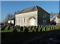
Quaker Meeting House and burial ground, Long Sutton
Image: © Roger Cornfoot
Taken: 25 Jan 2017
0.04 miles
3
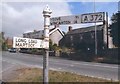
Old Direction Sign - Signpost by the A372, Shute Lane, Long Sutton Parish
Pyramid finial - 3 arms; Somerset SCC pyramid (Sheldon) by the A372, in parish of Long Sutton (South Somerset District), Shute Lane junction with Langport Road.
Surveyed
Milestone Society National ID: SO_ST4625B
Image: © Milestone Society
Taken: Unknown
0.05 miles
4

Quaker Meeting House and burial ground
A simple and elegant building, dating from about 1717.
Image: © Ken Grainger
Taken: 17 Oct 2008
0.05 miles
7
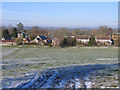
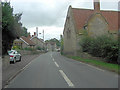
Long Sutton, Somerset
View W from the B3165; houses on Shute Lane.
Image: © Rodney Burton
Taken: 2 Mar 2006
0.18 miles

9
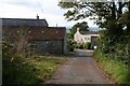
Farm buildings
This is Munday's Court, which is on Monday's Court Lane. Beyond are the Somerset Levels.
Image: © Neville Goodman
Taken: 22 Sep 2007
0.22 miles
10
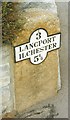
Old Milestone by the A372, Langport Road, north west of Long Sutton
Metal plate attached to stone post by the A372, in parish of LONG SUTTON (SOUTH SOMERSET District), half mile North West of Long Sutton, set in domestic garden wall, on North side of road. LSCC iron plate, erected by the Langport, Somerton & Castle Cary turnpike trust in the 20th century.
Inscription reads:-
3
LANGPORT
ILCHESTER
5¼
Grade II listed. List Entry Number: 1056596
https://historicengland.org.uk/listing/the-list/list-entry/1056596
Milestone Society National ID: SO_LPIC03.
Image: © M Dixon
Taken: 1 Dec 2001
0.25 miles