IMAGES TAKEN NEAR TO
Batts Lane, LANGPORT, TA10 9EQ
Introduction
This page details the photographs taken nearby to Batts Lane, TA10 9EQ by members of the Geograph project.
The Geograph project started in 2005 with the aim of publishing, organising and preserving representative images for every square kilometre of Great Britain, Ireland and the Isle of Man.

There are currently over 7.5m images from over14,400 individuals and you can help contribute to the project by visiting https://www.geograph.org.uk
Image Map
Images are licensed for reuse under creativecommons.org/licenses/by-sa/2.0
Notes
- Clicking on the map will re-center to the selected point.
- The higher the marker number, the further away the image location is from the centre of the postcode.
Image Listing (6 Images Found)
Images are licensed for reuse under creativecommons.org/licenses/by-sa/2.0
Image
Details
Distance
2
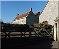
Buildings at Batt's Corner Farm
This is no longer a working farm and the property now consists of three separate large residences. Batt's Corner is where Vedal Drove meets Batt's Lane.
Image: © Nigel Mykura
Taken: 28 Dec 2016
0.05 miles
4

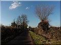
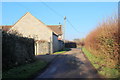
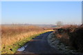
Batt's Lane
This quiet lane leads from Upton past Batt's Corner Farm to Ablake Lane.
Image: © Nigel Mykura
Taken: 28 Dec 2016
0.20 miles
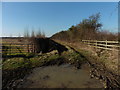
5
Vedal Drove
Vedal Drove leads from Batt's Corner on Batt's Lane down to the River Ivel or Yeo on Hay Moor. It is a dead end access road to farmers fields.
Image: © Nigel Mykura
Taken: 28 Dec 2016
0.25 miles