IMAGES TAKEN NEAR TO
Wearne, LANGPORT, TA10 0QQ
Introduction
This page details the photographs taken nearby to TA10 0QQ by members of the Geograph project.
The Geograph project started in 2005 with the aim of publishing, organising and preserving representative images for every square kilometre of Great Britain, Ireland and the Isle of Man.

There are currently over 7.5m images from over14,400 individuals and you can help contribute to the project by visiting https://www.geograph.org.uk
Image Map (Loading...)


Getting Data...Please wait
Leaflet Map data © OpenStreetMap
Images are licensed for reuse under creativecommons.org/licenses/by-sa/2.0
Notes
- Clicking on the map will re-center to the selected point.
- The higher the marker number, the further away the image location is from the centre of the postcode.
Image Listing (7 Images Found)
Images are licensed for reuse under creativecommons.org/licenses/by-sa/2.0
Image
Details
Distance
1
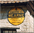
Old circular AA Sign in Wearne
Old AA Sign on the west facing wall of an outbuilding of Bay Farm on the north side of the road in Wearne, 1 mile north of Langport. Huish Episcopi parish.
This is the circular, village name on black band, no Motor Union symbol or name type, dating from 1923, and showing distances Somerton 4¼ Langport 1 London 129½.
There were five series of AA signs, mostly dating from 1923 and made by Francis & Co / Franco in Deptford, London. The village name and distance to London were usually displayed.
See also https://www.flickr.com/photos/142081890@N05/41598283510.
Milestone Society National ID: SO-WEARN
Image: © Milestone Society
Taken: Unknown
0.06 miles
3
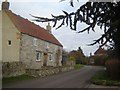
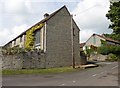
"Sawtell's Farm", Wearne, Somerset
Wearne is a linear village, and this house is on the main street. Farm buildings dominate the village.
Image: © Ruth Sharville
Taken: 27 Jan 2007
0.23 miles
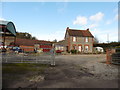
5
Combe Lane
Just the one "o", although on the right here is Image
Image: © Derek Harper
Taken: 13 Apr 2019
0.23 miles
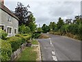
7
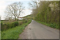
Lane from Wearne
Approaching the junction with the A372 at White Hill.
Image: © Derek Harper
Taken: 13 Apr 2019
0.25 miles