IMAGES TAKEN NEAR TO
Wiltown, LANGPORT, TA10 0HZ
Introduction
This page details the photographs taken nearby to Wiltown, TA10 0HZ by members of the Geograph project.
The Geograph project started in 2005 with the aim of publishing, organising and preserving representative images for every square kilometre of Great Britain, Ireland and the Isle of Man.

There are currently over 7.5m images from over14,400 individuals and you can help contribute to the project by visiting https://www.geograph.org.uk
Image Map (Loading...)


Getting Data...Please wait
Leaflet Map data © OpenStreetMap
Images are licensed for reuse under creativecommons.org/licenses/by-sa/2.0
Notes
- Clicking on the map will re-center to the selected point.
- The higher the marker number, the further away the image location is from the centre of the postcode.
Image Listing (5 Images Found)
Images are licensed for reuse under creativecommons.org/licenses/by-sa/2.0
Image
Details
Distance
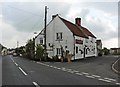
2
The King William IV, Curry Rivel
The pub stands beside the A378, the High Street. For a closer view of the sign Image
Image: © Maigheach-gheal
Taken: 5 May 2010
0.23 miles
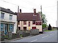
3
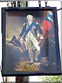
Sign for the King William IV
King William IV (1765-1837). He reigned from 26 June 1830 to 20 June 1837. The sign is a copy of the painting of the King in dress uniform by Sir Martin Archer, circa 1800.
Image: © Maigheach-gheal
Taken: 5 May 2010
0.24 miles