IMAGES TAKEN NEAR TO
Brimfield, LUDLOW, SY8 4NE
Introduction
This page details the photographs taken nearby to SY8 4NE by members of the Geograph project.
The Geograph project started in 2005 with the aim of publishing, organising and preserving representative images for every square kilometre of Great Britain, Ireland and the Isle of Man.

There are currently over 7.5m images from over14,400 individuals and you can help contribute to the project by visiting https://www.geograph.org.uk
Image Map
Images are licensed for reuse under creativecommons.org/licenses/by-sa/2.0
Notes
- Clicking on the map will re-center to the selected point.
- The higher the marker number, the further away the image location is from the centre of the postcode.
Image Listing (82 Images Found)
Images are licensed for reuse under creativecommons.org/licenses/by-sa/2.0
Image
Details
Distance
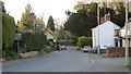
1
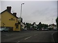
Brimfield
The former A49, which now bypasses the village to the west.
Image: © Richard Webb
Taken: 3 Apr 2013
0.02 miles
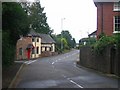
2
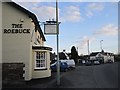
The Roebuck
Brimfield's pub, still very much centred on food.
Image: © Richard Webb
Taken: 3 Apr 2013
0.03 miles
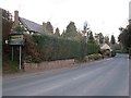
3
Brimfield
The former A49 is now a quiet village street. There used to be two shops here: Francis and a VG franchise. The pub (Roebuck) survives and is also home to the post office.
Image: © Richard Webb
Taken: 9 Apr 2014
0.03 miles
4
Brimfield
Village centre. I remember a shop and filling station here, long gone. The pub survives as an upmarket eating place. I used to ford the Teme to drink here at lunchtimes. The village has expanded quite dramatically over the years, and is now bypassed.
Image: © Richard Webb
Taken: 11 Sep 2005
0.03 miles
5
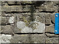
Old Bridge Marker on the former A49 at Brimfield
Bridge Marker set in the parapet of the bridge over Brimfield Brook on east side of the former A49. Brimfield parish. Inscribed H.C.C./ 79
Milestone Society National ID: HF_BRIM01br
Image: © Roadside Relics
Taken: 5 Jun 2023
0.10 miles
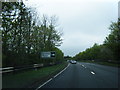
6
Brimfield
The old A49, now quiet since the bypass, built in the 1970's. This is the northern part of the old village. Growth here is curtailed by the presence of the Shropshire border, South Shropshire Council does not encourage development of villages , unlike the two Herefordshire (pre 1974 and post 1997) and Leominster councils have. Comparing Caynham and the Ashfords with Orleton and Brimfield shows the difference in policy quite clearly.
Image: © Richard Webb
Taken: 11 Sep 2005
0.12 miles
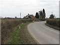
8
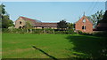
The Court Farm (Brimfield)
Here is the Court Farm by the parish church of St. Michael in Brimfield, taken from the car park provided for churchgoers to the previously mentioned church.
Image: © Fabian Musto
Taken: 20 Sep 2020
0.19 miles
9
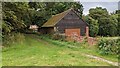
The Court Farm (Brimfield)
Here is a structure in the grounds of Court Farm, taken from outside the parish church of St. Michael.
Image: © Fabian Musto
Taken: 11 Aug 2021
0.19 miles