IMAGES TAKEN NEAR TO
Brimfield, LUDLOW, SY8 4ND
Introduction
This page details the photographs taken nearby to SY8 4ND by members of the Geograph project.
The Geograph project started in 2005 with the aim of publishing, organising and preserving representative images for every square kilometre of Great Britain, Ireland and the Isle of Man.

There are currently over 7.5m images from over14,400 individuals and you can help contribute to the project by visiting https://www.geograph.org.uk
Image Map (Loading...)


Getting Data...Please wait
Leaflet Map data © OpenStreetMap
Images are licensed for reuse under creativecommons.org/licenses/by-sa/2.0
Notes
- Clicking on the map will re-center to the selected point.
- The higher the marker number, the further away the image location is from the centre of the postcode.
Image Listing (6 Images Found)
Images are licensed for reuse under creativecommons.org/licenses/by-sa/2.0
Image
Details
Distance
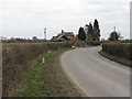
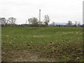
3
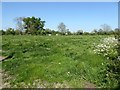
Farmland near Brimfield
Field near Gosford Farm to the east of Brimfield.
Image: © Philip Halling
Taken: 10 May 2017
0.21 miles
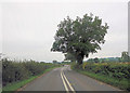
5
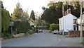
Brimfield
The former A49 is now a quiet village street. There used to be two shops here: Francis and a VG franchise. The pub (Roebuck) survives and is also home to the post office.
Image: © Richard Webb
Taken: 9 Apr 2014
0.24 miles
6
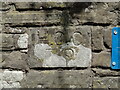
Old Bridge Marker on the former A49 at Brimfield
Bridge Marker set in the parapet of the bridge over Brimfield Brook on east side of the former A49. Brimfield parish. Inscribed H.C.C./ 79
Milestone Society National ID: HF_BRIM01br
Image: © Roadside Relics
Taken: 5 Jun 2023
0.25 miles