IMAGES TAKEN NEAR TO
Clee Hill, LUDLOW, SY8 3NY
Introduction
This page details the photographs taken nearby to SY8 3NY by members of the Geograph project.
The Geograph project started in 2005 with the aim of publishing, organising and preserving representative images for every square kilometre of Great Britain, Ireland and the Isle of Man.

There are currently over 7.5m images from over14,400 individuals and you can help contribute to the project by visiting https://www.geograph.org.uk
Image Map (Loading...)


Getting Data...Please wait
Leaflet Map data © OpenStreetMap
Images are licensed for reuse under creativecommons.org/licenses/by-sa/2.0
Notes
- Clicking on the map will re-center to the selected point.
- The higher the marker number, the further away the image location is from the centre of the postcode.
Image Listing (235 Images Found)
Images are licensed for reuse under creativecommons.org/licenses/by-sa/2.0
Image
Details
Distance
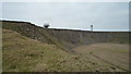
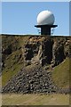
1
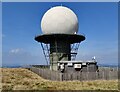
National Air Traffic Services radar network dome
Close to the summit of Titterstone Clee Hill, the third-highest hill in Shropshire at 533m (1,749 ft).
Image: © Mat Fascione
Taken: 6 Sep 2021
0.01 miles
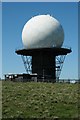
2
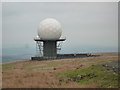
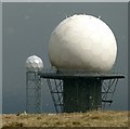
The "Golf Ball" Radar at Titterstone Clee Hill
As its common nickname goes, this "golf ball" radar is used for air-traffic control, and this is placed on top of the summit at Titterstone Clee hill.
Image: © Fabian Musto
Taken: 3 Jan 2019
0.01 miles
3
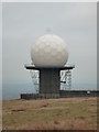
The "Golf Ball" Radar at Titterstone Clee Hill
As its common nickname goes, this "golf ball" radar is used for air-traffic control, and this is placed on top of the summit at Titterstone Clee hill.
Image: © Fabian Musto
Taken: 3 Jan 2019
0.01 miles
4
Radar Beacons at Titterstone Clee Hill
These two radar beacons have a sporty-like appearance to them, as the one on the left is often called the "golf-ball", whilst the one on the right is called the "football". The radar beacon on the left is used for air-traffic control, whilst the radar beacon on the right is used for Met Office weather.
Image: © Fabian Musto
Taken: 3 Jan 2019
0.01 miles
5
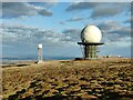
Radar domes on Titterstone Clee Hill
Titterstone Clee Hill is the third-highest hill in Shropshire at 533m (1,749 ft). The dome on the right is the National Air Traffic Services radar network, on the left is the Met Office weather radar station.
Image: © Mat Fascione
Taken: 5 Mar 2022
0.01 miles
6
Snow - balls
Radar station on Titterstone Clee in a snow flurry, with black clouds.
Image: © Alan Murray-Rust
Taken: 27 Apr 2016
0.01 miles
7
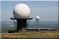
Radar domes on Titterstone Clee Hill
A pair of Radar domes, reminiscent of large golf balls, on the top of Titterstone Clee Hill. The larger of the two is part of the National Air Traffic Services (NATS) radar network, it monitors all aircraft within a 100-mile radius. The smaller radar dome in the background is part of the Met Office weather radar network. The larger of the two domes is visible from many miles making Titterstone Clee Hill instantly identifable.
Image: © Philip Halling
Taken: 14 May 2018
0.01 miles
8
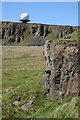
Air traffic control beacon
Air traffic control beacon on the summit of Titterstone Clee Hill. The beacon is part of the National Air Traffic Services (NATS) radar network, it monitors all aircraft within a 100-mile radius.
Image: © Philip Halling
Taken: 14 May 2018
0.01 miles
9
Air traffic control beacon
Air traffic control beacon on the summit of Titterstone Clee Hill. The beacon is part of the National Air Traffic Services (NATS) radar network, it monitors all aircraft within a 100-mile radius.
Image: © Philip Halling
Taken: 14 May 2018
0.01 miles
10
Air traffic control beacon
Air traffic control beacon on the summit of Titterstone Clee Hill. The beacon is part of the National Air Traffic Services (NATS) radar network, it monitors all aircraft within a 100-mile radius.
Image: © Philip Halling
Taken: 14 May 2018
0.01 miles