IMAGES TAKEN NEAR TO
Downton-on-the-Rock, LUDLOW, SY8 2LD
Introduction
This page details the photographs taken nearby to SY8 2LD by members of the Geograph project.
The Geograph project started in 2005 with the aim of publishing, organising and preserving representative images for every square kilometre of Great Britain, Ireland and the Isle of Man.

There are currently over 7.5m images from over14,400 individuals and you can help contribute to the project by visiting https://www.geograph.org.uk
Image Map
Images are licensed for reuse under creativecommons.org/licenses/by-sa/2.0
Notes
- Clicking on the map will re-center to the selected point.
- The higher the marker number, the further away the image location is from the centre of the postcode.
Image Listing (29 Images Found)
Images are licensed for reuse under creativecommons.org/licenses/by-sa/2.0
Image
Details
Distance
1
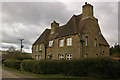
Brickyard Cottages
Presumably originally estate cottages for the Downton Estate. For closer view, see Image
Image: © Ian Capper
Taken: 28 Mar 2010
0.00 miles
2
Brickyard Cottages
Presumably originally estate cottages for the Downton Estate.
Image: © Ian Capper
Taken: 28 Mar 2010
0.01 miles
3
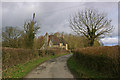
Cottage on the outskirts of Downton
Looking north-west from the crossroads.
Image: © Trevor Rickard
Taken: 10 Dec 2008
0.02 miles
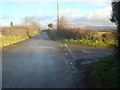
4
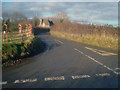
Crossroads
Where Forge Lane crosses the lane to Downton on the Rock. In the distance is Titterstone Clee Hill.
Image: © Ian Capper
Taken: 28 Mar 2010
0.07 miles
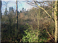
6
Pond near Brickyard Cottages
Brickyard Cottages are in the background (see Image). Was the pond created for brickmaking purposes?
Image: © Ian Capper
Taken: 28 Mar 2010
0.08 miles
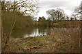
7
Pond at Downton
Large pond visible through the trees from the lane.
Image: © Trevor Rickard
Taken: 10 Dec 2008
0.08 miles
8
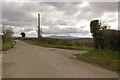
Lane junction near Downton
Looking eastwards along the lane to Lodge Farm. Turning for Forge Bridge on the right. In the distance Titterstone Clee Hill on the right and Brown Clee Hill just visible on the left.
Image: © Trevor Rickard
Taken: 10 Dec 2008
0.08 miles
9
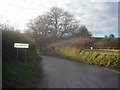
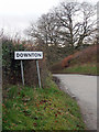
Downton village sign
Looking south-west from the crossroads.
Image: © Trevor Rickard
Taken: 10 Dec 2008
0.09 miles
10
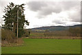
Towards Bringewood
Looking towards Bringewood (the wooded ridge in the background) from the footpath running for Brakes Farm to Forge Bridge.
Image: © Ian Capper
Taken: 28 Mar 2010
0.12 miles