IMAGES TAKEN NEAR TO
Lower Galdeford, LUDLOW, SY8 1SA
Introduction
This page details the photographs taken nearby to Lower Galdeford, SY8 1SA by members of the Geograph project.
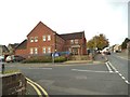
The Geograph project started in 2005 with the aim of publishing, organising and preserving representative images for every square kilometre of Great Britain, Ireland and the Isle of Man.

There are currently over 7.5m images from over14,400 individuals and you can help contribute to the project by visiting https://www.geograph.org.uk
Image Map
Images are licensed for reuse under creativecommons.org/licenses/by-sa/2.0
Notes
- Clicking on the map will re-center to the selected point.
- The higher the marker number, the further away the image location is from the centre of the postcode.
Image Listing (899 Images Found)
Images are licensed for reuse under creativecommons.org/licenses/by-sa/2.0
Image
Details
Distance
1
Ludlow Nick
The view of the Modern Police Station off Lower Galdeford.
Image: © Gordon Griffiths
Taken: 6 Oct 2013
0.00 miles
2
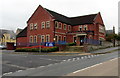
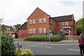
Ludlow Police Station
Part of the Shrewsbury Division of West Mercia Constabulary,
located on the corner of Lower Galdeford and Townsend Close.
Image: © Jaggery
Taken: 9 Nov 2015
0.00 miles
3
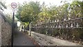
Friar's Walk
Spoilt by the usual prohibition and threats which despoil public places and make England such a pleasure to visit. Behind the railings is an old school (my old school).
Image: © Richard Webb
Taken: 9 Oct 2017
0.00 miles
4
Ludlow Police Station
Rebuilt in the Gordon Brown era, but not in the style of many from that time. This style cannot be described as anything more than functional.
Image: © Bill Boaden
Taken: 22 Aug 2018
0.01 miles
5
Ludlow Mascall Centre
Former school built in 1857, now serving as a conference centre, training facility and events venue.
Image: © Ian Capper
Taken: 10 Apr 2009
0.01 miles
6
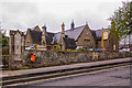
Towards Ludlow Castle and St Laurence's Church
Looking over Lower Galdeford (the road in the centre of the photo) from Gallows Bank with Ludlow Castle in the left background and St Laurence's Church on the right.
Image: © Ian Capper
Taken: 19 May 2016
0.01 miles
7
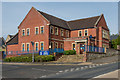
Ludlow Police Station
Police station in Lower Galdeford, serving the Ludlow policing neighbourhood in the West Mercia Police force area. The current building replaces an earlier one built further back, now replaced by Townsend Close - see Image Old maps show the site to have originally been a nursery.
Image: © Ian Capper
Taken: 19 May 2016
0.01 miles
8
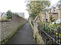
Friar's Walk
Running along the site of the town wall beside old school buildings. The building has been used by a variety of schools over the years. In 1972 St Lawrence School merged with the other (not C of E) school and moved to Clee View. Sometime later it resumed its independence at a new site on the old playing fields further down Friar's Walk.
On the left is the site of the police station, again replaced by a nearby modern building.
Image: © Richard Webb
Taken: 7 Apr 2014
0.01 miles
9
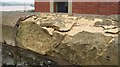
Frost damage
Frost damaged stonework outside Ludlow police station.
Image: © Richard Webb
Taken: 14 Feb 2009
0.01 miles
10
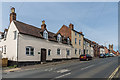
Lower Galdeford
Looking up Lower Galdeford with the tower of St Laurence's Church in the right background. The nearest building is nos. 65 and 66, a pair of 18th Century grade II listed cottages - see https://www.historicengland.org.uk/listing/the-list/list-entry/1290227. No 65 is named Tallow House and is adjacent to Chandlers Close, suggesting a local industry connected to the cattle market that once was once situated a short distance down Lower Galdeford.
Image: © Ian Capper
Taken: 19 May 2016
0.01 miles