IMAGES TAKEN NEAR TO
Hopton Heath, CRAVEN ARMS, SY7 0QD
Introduction
This page details the photographs taken nearby to SY7 0QD by members of the Geograph project.
The Geograph project started in 2005 with the aim of publishing, organising and preserving representative images for every square kilometre of Great Britain, Ireland and the Isle of Man.

There are currently over 7.5m images from over14,400 individuals and you can help contribute to the project by visiting https://www.geograph.org.uk
Image Map
Images are licensed for reuse under creativecommons.org/licenses/by-sa/2.0
Notes
- Clicking on the map will re-center to the selected point.
- The higher the marker number, the further away the image location is from the centre of the postcode.
Image Listing (22 Images Found)
Images are licensed for reuse under creativecommons.org/licenses/by-sa/2.0
Image
Details
Distance
1
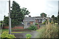
Weighbridge hut at Hopton Heath station
The former weighbridge and its stone built hut at the entrance to Hopton Heath railway station.
Image: © John Winder
Taken: 12 Jul 2015
0.01 miles
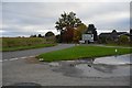
2
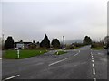
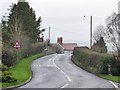
Road junction at Hoptonheath
At a bend in the B4385, where the B4367 joins it from the north-east
Image: © David Smith
Taken: 29 Nov 2014
0.02 miles
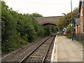
4
Bridge over railway at Hoptonheath station
Image: © David Smith
Taken: 29 Nov 2014
0.03 miles
6
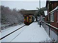
Hopton Heath railway station
Shropshire's quietest station at Hopton Heath, on a cold and snowy December morning. The 9.43 Shrewsbury-Llanelli service arriving.
http://en.wikipedia.org/wiki/Hopton_Heath_railway_station
http://en.wikipedia.org/wiki/Railways_of_Shropshire
Image: © Peter Evans
Taken: 4 Dec 2010
0.04 miles
7
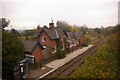
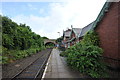
Hopton Heath Station
What is now marketed as the 'Heart of Wales' line, but was traditionally known as the Central Wales line, has many diminutive halts of which a handful, including this one, are actually in England. Hopton Heath (the Ordnance Survey gives the name for the settlement as one word, but the station has two) is surrounded by the deeply rural Clun valley and, unsurprisingly, passenger usage is low. Even so, when the station was built in 1861 it had two platforms and substantial buildings (now in private ownership). See Image for the same view in 2007.
Image: © Stephen McKay
Taken: 1 Apr 2018
0.05 miles
8
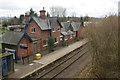
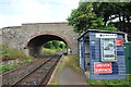
Hopton Heath station
Until recently, Hopton Heath was the least - used national rail network station in Shropshire, although now that dubious honour falls to Broome station which is just up the line. The Heart of Wales Line, which this is, was originally built as double track but has now been singled: careful scrutiny of the left hand side of the shot should reveal the stonework of the former Shrewsbury platform peeping through the undergrowth. The station building is now two private houses. A small hut next to the bridge at the end of the platform provides shelter for the many passengers who throng to the station every day.
Image: © John Winder
Taken: 12 Jul 2015
0.05 miles
9
Waiting room at Hopton Heath station
The rudimentary shelter for the hordes of passengers who use this station, until recently the least - used station in Shropshire. On the left can be seen the disused Shrewsbury platform, dating from when the line was double track.
Image: © John Winder
Taken: 12 Jul 2015
0.05 miles