IMAGES TAKEN NEAR TO
Kinton, Leintwardine, CRAVEN ARMS, SY7 0LT
Introduction
This page details the photographs taken nearby to SY7 0LT by members of the Geograph project.
The Geograph project started in 2005 with the aim of publishing, organising and preserving representative images for every square kilometre of Great Britain, Ireland and the Isle of Man.

There are currently over 7.5m images from over14,400 individuals and you can help contribute to the project by visiting https://www.geograph.org.uk
Image Map
Images are licensed for reuse under creativecommons.org/licenses/by-sa/2.0
Notes
- Clicking on the map will re-center to the selected point.
- The higher the marker number, the further away the image location is from the centre of the postcode.
Image Listing (14 Images Found)
Images are licensed for reuse under creativecommons.org/licenses/by-sa/2.0
Image
Details
Distance
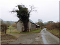
1
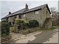
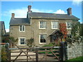
Kinton Farm (Leintwardine)
Here is Kinton Farm on Kinton Lane outside Leintwardine, which has an old hay barn close to it Image
Image: © Fabian Musto
Taken: 20 Mar 2021
0.02 miles
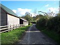
2
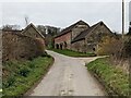
The Old Hay Barn (Leintwardine)
Here is an old hay barn on Kinton Lane, 60 metres south-east of Kinton Farm.
Image: © Fabian Musto
Taken: 20 Mar 2021
0.05 miles
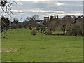
4
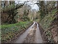
Kinton Lane (Leintwardine)
Here is Kinton Lane outside Leintwardine, situated south of the A4113 road.
Image: © Fabian Musto
Taken: 20 Mar 2021
0.13 miles
6
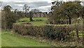
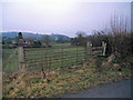
Green Acres (Leintwardine)
I believe this house is called Green Acres, and here it is from a public footpath by the primary school.
Image: © Fabian Musto
Taken: 20 Mar 2021
0.15 miles
8
St. Mary Magdalene church (Leintwardine)
The parish church of St. Mary Magdalene in Leintwardine is situated in northernmost Herefordshire, and the grade I listed church was established in the 12th century with restorations taken place in the 19th and 20th centuries. The bell tower dates from the 14th century and dominates the village from miles around.
Image: © Fabian Musto
Taken: 20 Mar 2021
0.17 miles
10
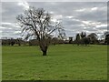
Tree and St. Mary Magdalene church (Leintwardine)
Taken on the first day of Spring 2021 from a public footpath by the primary school.
Image: © Fabian Musto
Taken: 20 Mar 2021
0.20 miles