IMAGES TAKEN NEAR TO
Morant View, SHREWSBURY, SY5 8QF
Introduction
This page details the photographs taken nearby to Morant View, SY5 8QF by members of the Geograph project.
The Geograph project started in 2005 with the aim of publishing, organising and preserving representative images for every square kilometre of Great Britain, Ireland and the Isle of Man.

There are currently over 7.5m images from over14,400 individuals and you can help contribute to the project by visiting https://www.geograph.org.uk
Image Map
Images are licensed for reuse under creativecommons.org/licenses/by-sa/2.0
Notes
- Clicking on the map will re-center to the selected point.
- The higher the marker number, the further away the image location is from the centre of the postcode.
Image Listing (17 Images Found)
Images are licensed for reuse under creativecommons.org/licenses/by-sa/2.0
Image
Details
Distance
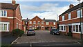
2
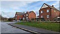
New homes and hedges
Built c. 2016? Not a new hedge per se - there was an old field boundary hedge here before the houses came anyway.
Image: © Andrew Abbott
Taken: 6 Jan 2023
0.09 miles
3
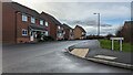
Squinter Pip Way
Looking west along Squinter Pip Way
Image: © Andrew Abbott
Taken: 6 Jan 2023
0.16 miles
5
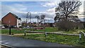
Drainage and new homes
Drainage features towards Rad Brook at new housing development (built c. 2015) just off Squinter Pip Way.
Image: © Andrew Abbott
Taken: 6 Jan 2023
0.17 miles
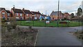
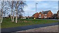
6
High density housing on Cavell Drive
Built in the early 2010s
Image: © Andrew Abbott
Taken: 6 Jan 2023
0.18 miles
7
Looking towards the attenuation pond at Whitty Close
Image: © Andrew Abbott
Taken: 6 Jan 2023
0.19 miles