IMAGES TAKEN NEAR TO
Pound Lane, SHREWSBURY, SY5 8JT
Introduction
This page details the photographs taken nearby to Pound Lane, SY5 8JT by members of the Geograph project.
The Geograph project started in 2005 with the aim of publishing, organising and preserving representative images for every square kilometre of Great Britain, Ireland and the Isle of Man.

There are currently over 7.5m images from over14,400 individuals and you can help contribute to the project by visiting https://www.geograph.org.uk
Image Map
Images are licensed for reuse under creativecommons.org/licenses/by-sa/2.0
Notes
- Clicking on the map will re-center to the selected point.
- The higher the marker number, the further away the image location is from the centre of the postcode.
Image Listing (4 Images Found)
Images are licensed for reuse under creativecommons.org/licenses/by-sa/2.0
Image
Details
Distance
1
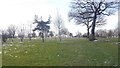
Arscott Golf Club
On former farmland, but also an area with an industrial heritage. This is the Shrewsbury coal field and there was a colliery nearby with associated brickworks.
Image: © Richard Webb
Taken: 19 Mar 2018
0.14 miles
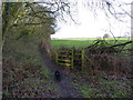
2
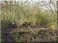
A dried lake, and a footpath
The map marks a lake or pool here, but frankly there's little but alder scrub and damp patches now.
Image: © Richard Law
Taken: 28 Jan 2012
0.15 miles